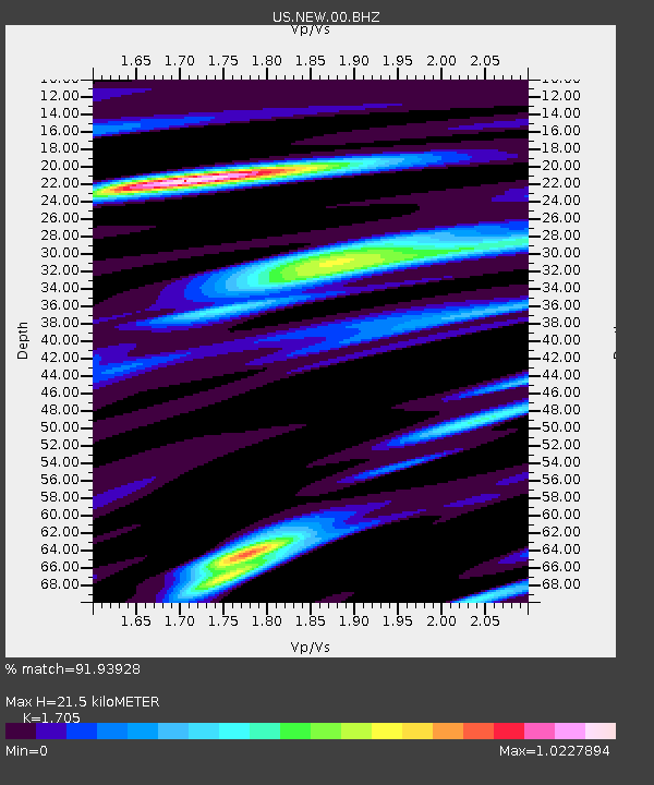
NEW Newport, Washington, USA - Earthquake Result Viewer

Earthquake location: Andreanof Islands, Aleutian Is.
Earthquake latitude/longitude: 51.6/-174.8
Earthquake time(UTC): 2013/09/04 (247) 02:32:30 GMT
Earthquake Depth: 20 km
Earthquake Magnitude: 6.5 MWW, 5.9 ML, 6.3 MWB, 6.5 MI, 6.5 MWC, 6.5 MWW
Earthquake Catalog/Contributor: NEIC PDE/NEIC COMCAT
Network: US United States National Seismic Network
Station: NEW Newport, Washington, USA
Lat/Lon: 48.26 N/117.12 W
Elevation: 760 m
Distance: 36.4 deg
Az: 71.842 deg
Baz: 297.406 deg
Ray Param: 0.07665225
Estimated Moho Depth: 21.5 km
Estimated Crust Vp/Vs: 1.71
Assumed Crust Vp: 6.571 km/s
Estimated Crust Vs: 3.854 km/s
Estimated Crust Poisson's Ratio: 0.24
Radial Match: 91.93928 %
Radial Bump: 400
Transverse Match: 74.90866 %
Transverse Bump: 400
SOD ConfigId: 626651
Insert Time: 2014-04-18 10:26:57.459 +0000
GWidth: 2.5
Max Bumps: 400
Tol: 0.001

Signal To Noise

ChannelStoNSTALTA
US:NEW:00:BHZ:20130904T02:39:03.249994Z4.7838296.548371E-71.3688556E-7
US:NEW:00:BH1:20130904T02:39:03.249994Z1.48301511.952414E-71.3165166E-7
US:NEW:00:BH2:20130904T02:39:03.249994Z1.29371322.581952E-71.9957685E-7
Arrivals
Ps2.5 SECOND
PpPs8.2 SECOND
PsPs/PpSs11 SECOND