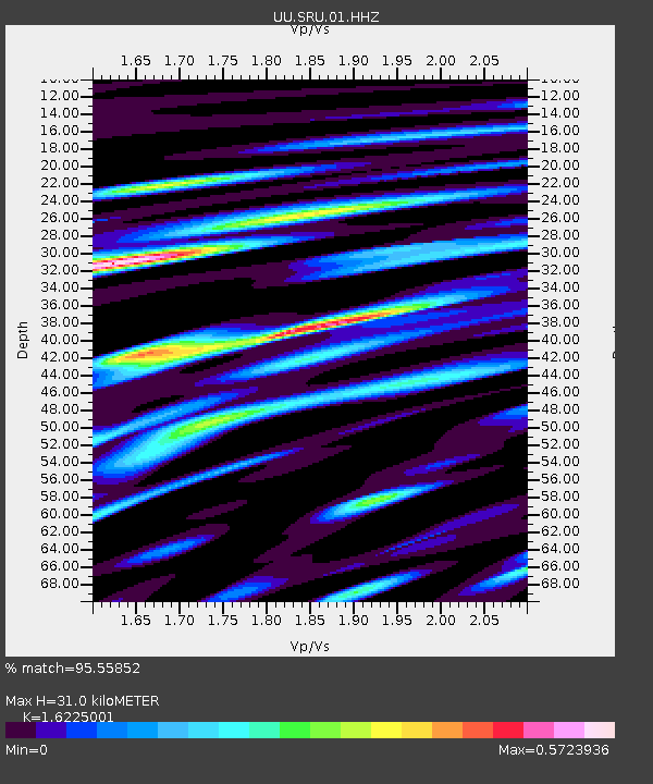
SRU San Rafael Swell, UT, USA - Earthquake Result Viewer

Earthquake location: Andreanof Islands, Aleutian Is.
Earthquake latitude/longitude: 51.6/-174.8
Earthquake time(UTC): 2013/09/04 (247) 02:32:30 GMT
Earthquake Depth: 20 km
Earthquake Magnitude: 6.5 MWW, 5.9 ML, 6.3 MWB, 6.5 MI, 6.5 MWC, 6.5 MWW
Earthquake Catalog/Contributor: NEIC PDE/NEIC COMCAT
Network: UU University of Utah Regional Network
Station: SRU San Rafael Swell, UT, USA
Lat/Lon: 39.11 N/110.52 W
Elevation: 1804 m
Distance: 45.4 deg
Az: 79.638 deg
Baz: 307.875 deg
Ray Param: 0.07126049
Estimated Moho Depth: 31.0 km
Estimated Crust Vp/Vs: 1.62
Assumed Crust Vp: 6.207 km/s
Estimated Crust Vs: 3.825 km/s
Estimated Crust Poisson's Ratio: 0.19
Radial Match: 95.55852 %
Radial Bump: 400
Transverse Match: 79.324356 %
Transverse Bump: 400
SOD ConfigId: 626651
Insert Time: 2014-04-18 10:28:07.819 +0000
GWidth: 2.5
Max Bumps: 400
Tol: 0.001

Signal To Noise

ChannelStoNSTALTA
UU:SRU:01:HHZ:20130904T02:40:17.08999Z3.42633444.5557013E-71.3296138E-7
UU:SRU:01:HHN:20130904T02:40:17.08999Z3.77739762.3110921E-76.118212E-8
UU:SRU:01:HHE:20130904T02:40:17.08999Z1.86966471.9754447E-71.056577E-7
Arrivals
Ps3.3 SECOND
PpPs12 SECOND
PsPs/PpSs16 SECOND