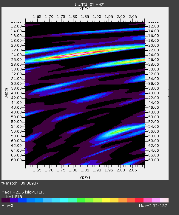
TCU Toone Canyon, UT, USA - Earthquake Result Viewer

Earthquake location: Andreanof Islands, Aleutian Is.
Earthquake latitude/longitude: 51.6/-174.8
Earthquake time(UTC): 2013/09/04 (247) 02:32:30 GMT
Earthquake Depth: 20 km
Earthquake Magnitude: 6.5 MWW, 5.9 ML, 6.3 MWB, 6.5 MI, 6.5 MWC, 6.5 MWW
Earthquake Catalog/Contributor: NEIC PDE/NEIC COMCAT
Network: UU University of Utah Regional Network
Station: TCU Toone Canyon, UT, USA
Lat/Lon: 41.12 N/111.41 W
Elevation: 2269 m
Distance: 43.7 deg
Az: 77.938 deg
Baz: 306.096 deg
Ray Param: 0.072370514
Estimated Moho Depth: 23.5 km
Estimated Crust Vp/Vs: 1.82
Assumed Crust Vp: 6.155 km/s
Estimated Crust Vs: 3.391 km/s
Estimated Crust Poisson's Ratio: 0.28
Radial Match: 89.86937 %
Radial Bump: 400
Transverse Match: 81.638985 %
Transverse Bump: 400
SOD ConfigId: 626651
Insert Time: 2014-04-18 10:28:17.128 +0000
GWidth: 2.5
Max Bumps: 400
Tol: 0.001

Signal To Noise

ChannelStoNSTALTA
UU:TCU:01:HHZ:20130904T02:40:03.15899Z4.6803461.8616268E-83.977541E-9
UU:TCU:01:HHN:20130904T02:40:03.15899Z1.73908275.9322227E-93.4111216E-9
UU:TCU:01:HHE:20130904T02:40:03.15899Z1.3711378.306635E-96.0582095E-9
Arrivals
Ps3.3 SECOND
PpPs10 SECOND
PsPs/PpSs13 SECOND