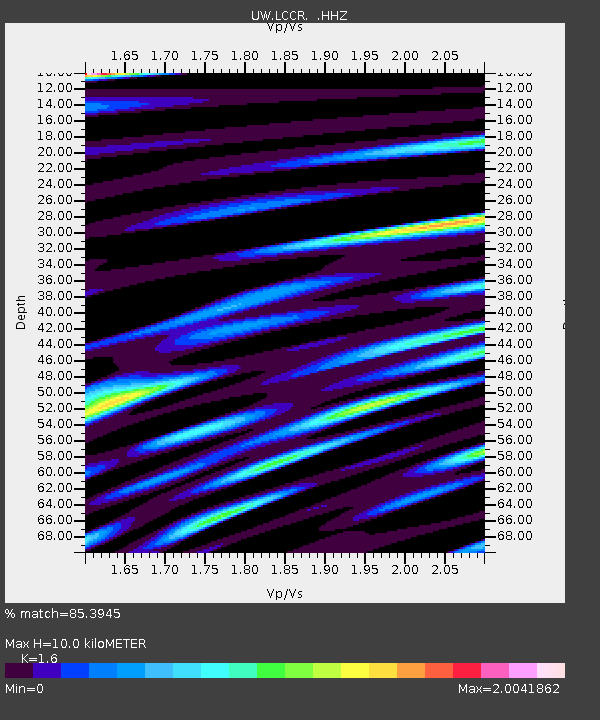
LCCR Mulino, OR, USA - Earthquake Result Viewer

Earthquake location: Andreanof Islands, Aleutian Is.
Earthquake latitude/longitude: 51.6/-174.8
Earthquake time(UTC): 2013/09/04 (247) 02:32:30 GMT
Earthquake Depth: 20 km
Earthquake Magnitude: 6.5 MWW, 5.9 ML, 6.3 MWB, 6.5 MI, 6.5 MWC, 6.5 MWW
Earthquake Catalog/Contributor: NEIC PDE/NEIC COMCAT
Network: UW Pacific Northwest Regional Seismic Network
Station: LCCR Mulino, OR, USA
Lat/Lon: 45.21 N/122.48 W
Elevation: 273 m
Distance: 34.7 deg
Az: 79.491 deg
Baz: 299.741 deg
Ray Param: 0.07759983
Estimated Moho Depth: 10.0 km
Estimated Crust Vp/Vs: 1.60
Assumed Crust Vp: 6.566 km/s
Estimated Crust Vs: 4.104 km/s
Estimated Crust Poisson's Ratio: 0.18
Radial Match: 85.3945 %
Radial Bump: 400
Transverse Match: 57.00676 %
Transverse Bump: 400
SOD ConfigId: 626651
Insert Time: 2014-04-18 10:28:43.870 +0000
GWidth: 2.5
Max Bumps: 400
Tol: 0.001

Signal To Noise

ChannelStoNSTALTA
UW:LCCR: :HHZ:20130904T02:38:48.017999Z3.41508824.8863325E-71.4308071E-7
UW:LCCR: :HHN:20130904T02:38:48.017999Z1.3022592.2841527E-71.7539926E-7
UW:LCCR: :HHE:20130904T02:38:48.017999Z0.88787292.2760464E-72.5634824E-7
Arrivals
Ps1.0 SECOND
PpPs3.6 SECOND
PsPs/PpSs4.6 SECOND