You are here: Home > Network List > UW - Pacific Northwest Regional Seismic Network Stations List
> Station LEBA Lebam, WA, USA > Earthquake Result Viewer
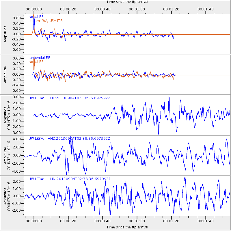
LEBA Lebam, WA, USA - Earthquake Result Viewer
*The percent match for this event was below the threshold and hence no stack was calculated.
| Earthquake location: |
Andreanof Islands, Aleutian Is. |
| Earthquake latitude/longitude: |
51.6/-174.8 |
| Earthquake time(UTC): |
2013/09/04 (247) 02:32:30 GMT |
| Earthquake Depth: |
20 km |
| Earthquake Magnitude: |
6.5 MWW, 5.9 ML, 6.3 MWB, 6.5 MI, 6.5 MWC, 6.5 MWW |
| Earthquake Catalog/Contributor: |
NEIC PDE/NEIC COMCAT |
|
| Network: |
UW Pacific Northwest Regional Seismic Network |
| Station: |
LEBA Lebam, WA, USA |
| Lat/Lon: |
46.55 N/123.56 W |
| Elevation: |
73 m |
|
| Distance: |
33.4 deg |
| Az: |
78.043 deg |
| Baz: |
297.764 deg |
| Ray Param: |
$rayparam |
*The percent match for this event was below the threshold and hence was not used in the summary stack. |
|
| Radial Match: |
71.44496 % |
| Radial Bump: |
400 |
| Transverse Match: |
71.04543 % |
| Transverse Bump: |
400 |
| SOD ConfigId: |
626651 |
| Insert Time: |
2014-04-18 10:28:44.406 +0000 |
| GWidth: |
2.5 |
| Max Bumps: |
400 |
| Tol: |
0.001 |
|
Signal To Noise
| Channel | StoN | STA | LTA |
| UW:LEBA: :HHZ:20130904T02:38:36.697992Z | 4.318966 | 5.735832E-7 | 1.3280567E-7 |
| UW:LEBA: :HHN:20130904T02:38:36.697992Z | 1.1159521 | 1.7086687E-7 | 1.5311309E-7 |
| UW:LEBA: :HHE:20130904T02:38:36.697992Z | 0.7850264 | 1.7073832E-7 | 2.1749375E-7 |
| Arrivals |
| Ps | |
| PpPs | |
| PsPs/PpSs | |


