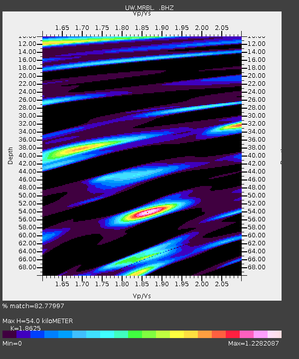
MRBL Marblemount, WA, USA - Earthquake Result Viewer
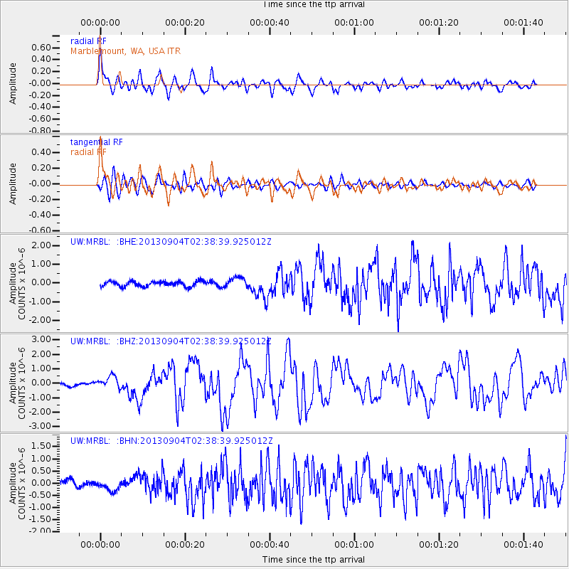
Earthquake location: Andreanof Islands, Aleutian Is.
Earthquake latitude/longitude: 51.6/-174.8
Earthquake time(UTC): 2013/09/04 (247) 02:32:30 GMT
Earthquake Depth: 20 km
Earthquake Magnitude: 6.5 MWW, 5.9 ML, 6.3 MWB, 6.5 MI, 6.5 MWC, 6.5 MWW
Earthquake Catalog/Contributor: NEIC PDE/NEIC COMCAT
Network: UW Pacific Northwest Regional Seismic Network
Station: MRBL Marblemount, WA, USA
Lat/Lon: 48.52 N/121.48 W
Elevation: 75 m
Distance: 33.7 deg
Az: 73.706 deg
Baz: 295.677 deg
Ray Param: 0.07805251
Estimated Moho Depth: 54.0 km
Estimated Crust Vp/Vs: 1.86
Assumed Crust Vp: 6.566 km/s
Estimated Crust Vs: 3.525 km/s
Estimated Crust Poisson's Ratio: 0.30
Radial Match: 82.77997 %
Radial Bump: 400
Transverse Match: 70.66138 %
Transverse Bump: 400
SOD ConfigId: 626651
Insert Time: 2014-04-18 10:28:53.190 +0000
GWidth: 2.5
Max Bumps: 400
Tol: 0.001

Signal To Noise

ChannelStoNSTALTA
UW:MRBL: :BHZ:20130904T02:38:39.925012Z3.96953374.335468E-71.0921857E-7
UW:MRBL: :BHN:20130904T02:38:39.925012Z1.43977572.123211E-71.4746817E-7
UW:MRBL: :BHE:20130904T02:38:39.925012Z1.99336392.739655E-71.3743878E-7
Arrivals
Ps7.7 SECOND
PpPs22 SECOND
PsPs/PpSs29 SECOND