You are here: Home > Network List > II - Global Seismograph Network (GSN - IRIS/IDA) Stations List
> Station WRAB Tennant Creek, NT, Australia > Earthquake Result Viewer
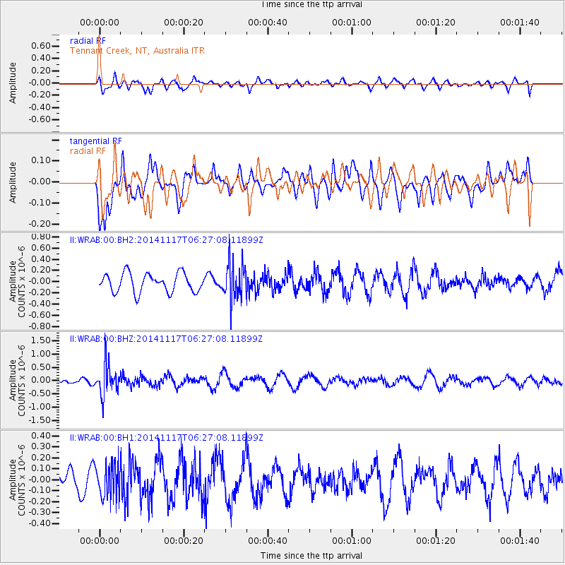
WRAB Tennant Creek, NT, Australia - Earthquake Result Viewer
*The percent match for this event was below the threshold and hence no stack was calculated.
| Earthquake location: |
Fiji Islands Region |
| Earthquake latitude/longitude: |
-21.6/-179.2 |
| Earthquake time(UTC): |
2014/11/17 (321) 06:20:29 GMT |
| Earthquake Depth: |
614 km |
| Earthquake Magnitude: |
5.5 MW, 4.8 mb |
| Earthquake Catalog/Contributor: |
ISC/ISC |
|
| Network: |
II Global Seismograph Network (GSN - IRIS/IDA) |
| Station: |
WRAB Tennant Creek, NT, Australia |
| Lat/Lon: |
19.93 S/134.36 E |
| Elevation: |
366 m |
|
| Distance: |
43.3 deg |
| Az: |
263.429 deg |
| Baz: |
100.616 deg |
| Ray Param: |
$rayparam |
*The percent match for this event was below the threshold and hence was not used in the summary stack. |
|
| Radial Match: |
49.433414 % |
| Radial Bump: |
400 |
| Transverse Match: |
51.808186 % |
| Transverse Bump: |
400 |
| SOD ConfigId: |
3390531 |
| Insert Time: |
2019-04-15 01:28:00.125 +0000 |
| GWidth: |
2.5 |
| Max Bumps: |
400 |
| Tol: |
0.001 |
|
Signal To Noise
| Channel | StoN | STA | LTA |
| II:WRAB:00:BHZ:20141117T06:27:08.11899Z | 5.600984 | 5.727254E-7 | 1.0225443E-7 |
| II:WRAB:00:BH1:20141117T06:27:08.11899Z | 1.858397 | 1.4711337E-7 | 7.9161424E-8 |
| II:WRAB:00:BH2:20141117T06:27:08.11899Z | 1.8819897 | 3.1385554E-7 | 1.6676793E-7 |
| Arrivals |
| Ps | |
| PpPs | |
| PsPs/PpSs | |


