You are here: Home > Network List > TA - USArray Transportable Network (new EarthScope stations) Stations List
> Station D41A Chassel, MI, USA > Earthquake Result Viewer
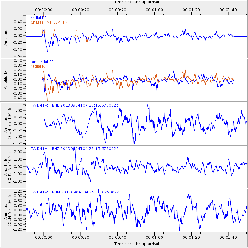
D41A Chassel, MI, USA - Earthquake Result Viewer
*The percent match for this event was below the threshold and hence no stack was calculated.
| Earthquake location: |
Andreanof Islands, Aleutian Is. |
| Earthquake latitude/longitude: |
51.4/-174.7 |
| Earthquake time(UTC): |
2013/09/04 (247) 04:16:30 GMT |
| Earthquake Depth: |
27 km |
| Earthquake Magnitude: |
5.9 MW, 5.2 ML, 5.4 ML, 5.8 MWW, 5.8 MWW, 5.9 MWC |
| Earthquake Catalog/Contributor: |
NEIC PDE/NEIC COMCAT |
|
| Network: |
TA USArray Transportable Network (new EarthScope stations) |
| Station: |
D41A Chassel, MI, USA |
| Lat/Lon: |
47.06 N/88.57 W |
| Elevation: |
271 m |
|
| Distance: |
53.3 deg |
| Az: |
58.325 deg |
| Baz: |
308.835 deg |
| Ray Param: |
$rayparam |
*The percent match for this event was below the threshold and hence was not used in the summary stack. |
|
| Radial Match: |
77.796 % |
| Radial Bump: |
400 |
| Transverse Match: |
69.122154 % |
| Transverse Bump: |
400 |
| SOD ConfigId: |
626651 |
| Insert Time: |
2014-04-18 10:46:37.269 +0000 |
| GWidth: |
2.5 |
| Max Bumps: |
400 |
| Tol: |
0.001 |
|
Signal To Noise
| Channel | StoN | STA | LTA |
| TA:D41A: :BHZ:20130904T04:25:15.675002Z | 3.1789603 | 1.0873101E-6 | 3.4203325E-7 |
| TA:D41A: :BHN:20130904T04:25:15.675002Z | 1.2701166 | 3.984597E-7 | 3.13719E-7 |
| TA:D41A: :BHE:20130904T04:25:15.675002Z | 1.650359 | 7.320481E-7 | 4.4356898E-7 |
| Arrivals |
| Ps | |
| PpPs | |
| PsPs/PpSs | |


