You are here: Home > Network List > TA - USArray Transportable Network (new EarthScope stations) Stations List
> Station E43A Lone Tree Farm, Eben Junction, MI, USA > Earthquake Result Viewer
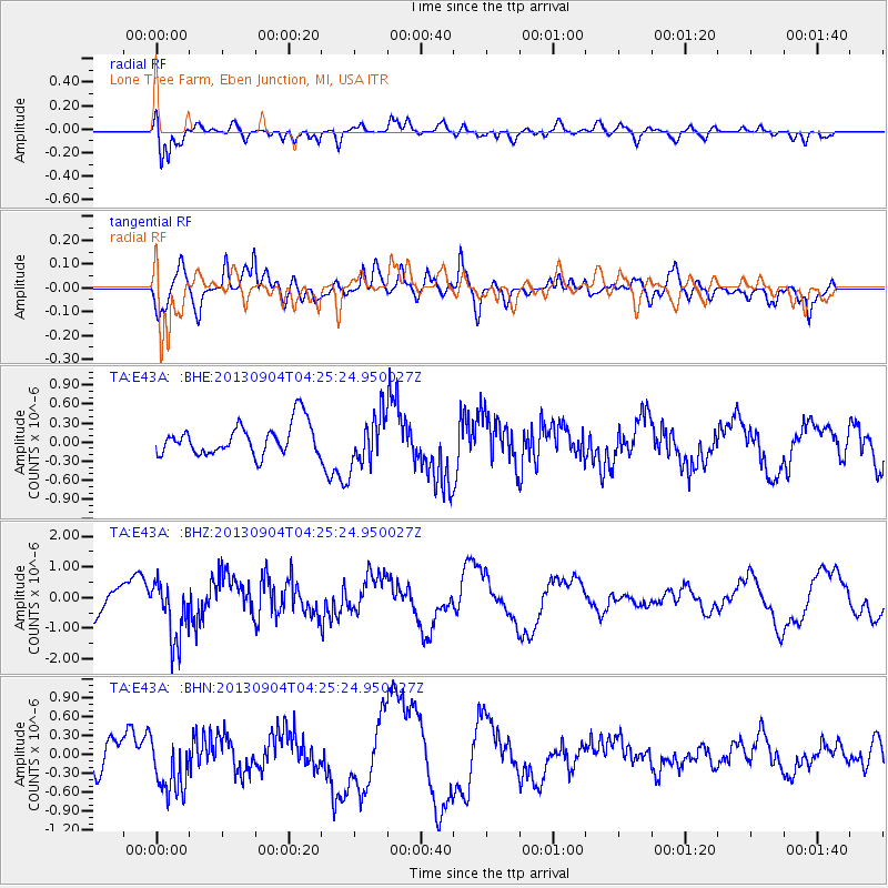
E43A Lone Tree Farm, Eben Junction, MI, USA - Earthquake Result Viewer
*The percent match for this event was below the threshold and hence no stack was calculated.
| Earthquake location: |
Andreanof Islands, Aleutian Is. |
| Earthquake latitude/longitude: |
51.4/-174.7 |
| Earthquake time(UTC): |
2013/09/04 (247) 04:16:30 GMT |
| Earthquake Depth: |
27 km |
| Earthquake Magnitude: |
5.9 MW, 5.2 ML, 5.4 ML, 5.8 MWW, 5.8 MWW, 5.9 MWC |
| Earthquake Catalog/Contributor: |
NEIC PDE/NEIC COMCAT |
|
| Network: |
TA USArray Transportable Network (new EarthScope stations) |
| Station: |
E43A Lone Tree Farm, Eben Junction, MI, USA |
| Lat/Lon: |
46.38 N/87.00 W |
| Elevation: |
303 m |
|
| Distance: |
54.5 deg |
| Az: |
58.133 deg |
| Baz: |
309.861 deg |
| Ray Param: |
$rayparam |
*The percent match for this event was below the threshold and hence was not used in the summary stack. |
|
| Radial Match: |
76.55251 % |
| Radial Bump: |
400 |
| Transverse Match: |
71.06529 % |
| Transverse Bump: |
400 |
| SOD ConfigId: |
626651 |
| Insert Time: |
2014-04-18 10:46:53.522 +0000 |
| GWidth: |
2.5 |
| Max Bumps: |
400 |
| Tol: |
0.001 |
|
Signal To Noise
| Channel | StoN | STA | LTA |
| TA:E43A: :BHZ:20130904T04:25:24.950027Z | 1.8066144 | 9.735941E-7 | 5.3890534E-7 |
| TA:E43A: :BHN:20130904T04:25:24.950027Z | 2.217122 | 4.4278218E-7 | 1.9971031E-7 |
| TA:E43A: :BHE:20130904T04:25:24.950027Z | 1.6062866 | 3.9175052E-7 | 2.438858E-7 |
| Arrivals |
| Ps | |
| PpPs | |
| PsPs/PpSs | |


