You are here: Home > Network List > TA - USArray Transportable Network (new EarthScope stations) Stations List
> Station J01E Myrtle Point, OR, USA > Earthquake Result Viewer
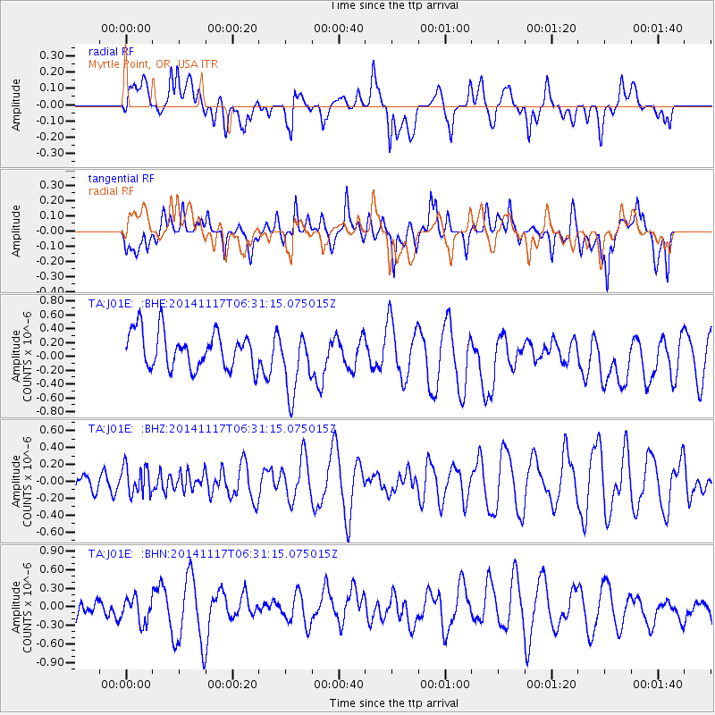
J01E Myrtle Point, OR, USA - Earthquake Result Viewer
*The percent match for this event was below the threshold and hence no stack was calculated.
| Earthquake location: |
Fiji Islands Region |
| Earthquake latitude/longitude: |
-21.6/-179.2 |
| Earthquake time(UTC): |
2014/11/17 (321) 06:20:29 GMT |
| Earthquake Depth: |
614 km |
| Earthquake Magnitude: |
5.5 MW, 4.8 mb |
| Earthquake Catalog/Contributor: |
ISC/ISC |
|
| Network: |
TA USArray Transportable Network (new EarthScope stations) |
| Station: |
J01E Myrtle Point, OR, USA |
| Lat/Lon: |
43.16 N/123.93 W |
| Elevation: |
128 m |
|
| Distance: |
82.0 deg |
| Az: |
37.391 deg |
| Baz: |
230.578 deg |
| Ray Param: |
$rayparam |
*The percent match for this event was below the threshold and hence was not used in the summary stack. |
|
| Radial Match: |
48.389854 % |
| Radial Bump: |
400 |
| Transverse Match: |
41.72325 % |
| Transverse Bump: |
400 |
| SOD ConfigId: |
3390531 |
| Insert Time: |
2019-04-15 01:29:17.853 +0000 |
| GWidth: |
2.5 |
| Max Bumps: |
400 |
| Tol: |
0.001 |
|
Signal To Noise
| Channel | StoN | STA | LTA |
| TA:J01E: :BHZ:20141117T06:31:15.075015Z | 0.46883774 | 1.6850713E-7 | 3.594146E-7 |
| TA:J01E: :BHN:20141117T06:31:15.075015Z | 0.9806605 | 1.9645671E-7 | 2.0033102E-7 |
| TA:J01E: :BHE:20141117T06:31:15.075015Z | 1.7635471 | 4.618098E-7 | 2.618642E-7 |
| Arrivals |
| Ps | |
| PpPs | |
| PsPs/PpSs | |


