You are here: Home > Network List > TA - USArray Transportable Network (new EarthScope stations) Stations List
> Station T52A Hallie, KY, USA > Earthquake Result Viewer
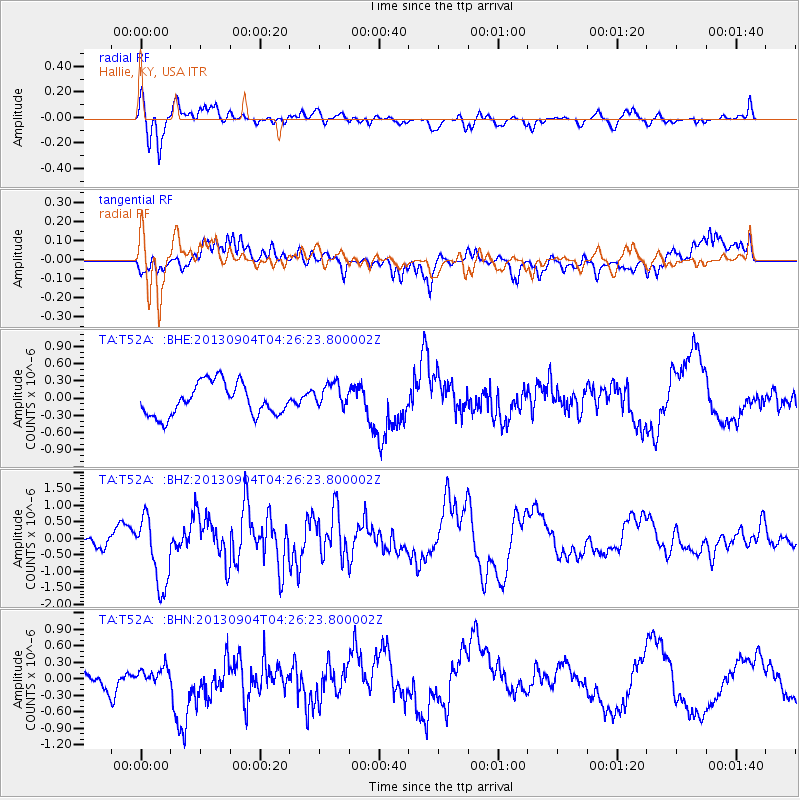
T52A Hallie, KY, USA - Earthquake Result Viewer
*The percent match for this event was below the threshold and hence no stack was calculated.
| Earthquake location: |
Andreanof Islands, Aleutian Is. |
| Earthquake latitude/longitude: |
51.4/-174.7 |
| Earthquake time(UTC): |
2013/09/04 (247) 04:16:30 GMT |
| Earthquake Depth: |
27 km |
| Earthquake Magnitude: |
5.9 MW, 5.2 ML, 5.4 ML, 5.8 MWW, 5.8 MWW, 5.9 MWC |
| Earthquake Catalog/Contributor: |
NEIC PDE/NEIC COMCAT |
|
| Network: |
TA USArray Transportable Network (new EarthScope stations) |
| Station: |
T52A Hallie, KY, USA |
| Lat/Lon: |
37.11 N/82.99 W |
| Elevation: |
436 m |
|
| Distance: |
63.0 deg |
| Az: |
63.709 deg |
| Baz: |
315.43 deg |
| Ray Param: |
$rayparam |
*The percent match for this event was below the threshold and hence was not used in the summary stack. |
|
| Radial Match: |
75.41332 % |
| Radial Bump: |
400 |
| Transverse Match: |
60.0973 % |
| Transverse Bump: |
400 |
| SOD ConfigId: |
626651 |
| Insert Time: |
2014-04-18 10:51:27.383 +0000 |
| GWidth: |
2.5 |
| Max Bumps: |
400 |
| Tol: |
0.001 |
|
Signal To Noise
| Channel | StoN | STA | LTA |
| TA:T52A: :BHZ:20130904T04:26:23.800002Z | 2.519921 | 1.0591904E-6 | 4.2032678E-7 |
| TA:T52A: :BHN:20130904T04:26:23.800002Z | 0.57882726 | 1.0392352E-7 | 1.7954152E-7 |
| TA:T52A: :BHE:20130904T04:26:23.800002Z | 0.8006922 | 2.2414473E-7 | 2.799387E-7 |
| Arrivals |
| Ps | |
| PpPs | |
| PsPs/PpSs | |


