You are here: Home > Network List > TA - USArray Transportable Network (new EarthScope stations) Stations List
> Station G57A Newington, ON, CAN > Earthquake Result Viewer
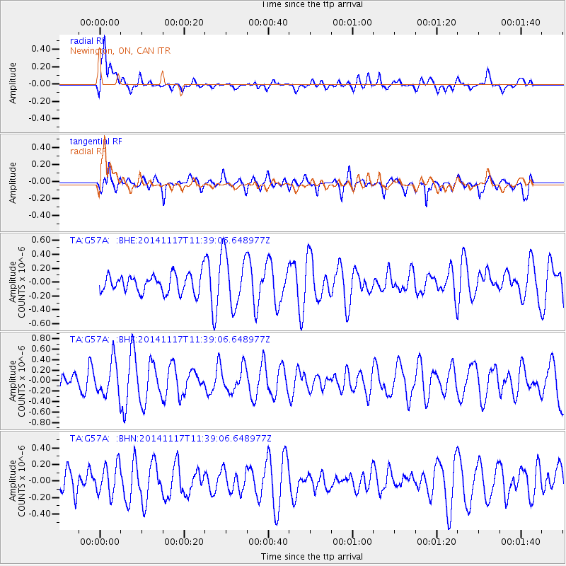
G57A Newington, ON, CAN - Earthquake Result Viewer
*The percent match for this event was below the threshold and hence no stack was calculated.
| Earthquake location: |
Southeast Of Easter Island |
| Earthquake latitude/longitude: |
-36.0/-102.2 |
| Earthquake time(UTC): |
2014/11/17 (321) 11:27:05 GMT |
| Earthquake Depth: |
10 km |
| Earthquake Magnitude: |
5.4 MW, 5.0 mb, 4.7 MS |
| Earthquake Catalog/Contributor: |
ISC/ISC |
|
| Network: |
TA USArray Transportable Network (new EarthScope stations) |
| Station: |
G57A Newington, ON, CAN |
| Lat/Lon: |
45.10 N/74.99 W |
| Elevation: |
96 m |
|
| Distance: |
84.4 deg |
| Az: |
19.025 deg |
| Baz: |
201.926 deg |
| Ray Param: |
$rayparam |
*The percent match for this event was below the threshold and hence was not used in the summary stack. |
|
| Radial Match: |
69.57491 % |
| Radial Bump: |
400 |
| Transverse Match: |
52.628574 % |
| Transverse Bump: |
400 |
| SOD ConfigId: |
3390531 |
| Insert Time: |
2019-04-15 01:35:42.934 +0000 |
| GWidth: |
2.5 |
| Max Bumps: |
400 |
| Tol: |
0.001 |
|
Signal To Noise
| Channel | StoN | STA | LTA |
| TA:G57A: :BHZ:20141117T11:39:06.648977Z | 1.9102165 | 3.3824793E-7 | 1.7707309E-7 |
| TA:G57A: :BHN:20141117T11:39:06.648977Z | 1.5298026 | 1.8677534E-7 | 1.2209114E-7 |
| TA:G57A: :BHE:20141117T11:39:06.648977Z | 2.9510913 | 3.8632578E-7 | 1.3090946E-7 |
| Arrivals |
| Ps | |
| PpPs | |
| PsPs/PpSs | |


