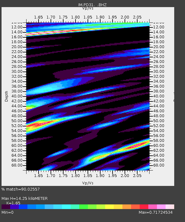
PD31 PDAR Array, Pinedale, WY, USA - Earthquake Result Viewer

Earthquake location: Andreanof Islands, Aleutian Is.
Earthquake latitude/longitude: 51.6/-174.8
Earthquake time(UTC): 2013/09/04 (247) 06:16:49 GMT
Earthquake Depth: 21 km
Earthquake Magnitude: 5.7 MWW, 5.5 ML, 5.5 MI, 5.7 MWB, 5.7 MWW, 5.8 MWC
Earthquake Catalog/Contributor: NEIC PDE/NEIC COMCAT
Network: IM International Miscellaneous Stations
Station: PD31 PDAR Array, Pinedale, WY, USA
Lat/Lon: 42.77 N/109.56 W
Elevation: 2219 m
Distance: 43.8 deg
Az: 74.841 deg
Baz: 305.116 deg
Ray Param: 0.07225502
Estimated Moho Depth: 14.25 km
Estimated Crust Vp/Vs: 1.65
Assumed Crust Vp: 6.161 km/s
Estimated Crust Vs: 3.734 km/s
Estimated Crust Poisson's Ratio: 0.21
Radial Match: 90.02557 %
Radial Bump: 400
Transverse Match: 90.35393 %
Transverse Bump: 400
SOD ConfigId: 626651
Insert Time: 2014-04-18 11:05:36.444 +0000
GWidth: 2.5
Max Bumps: 400
Tol: 0.001

Signal To Noise

ChannelStoNSTALTA
IM:PD31: :BHZ:20130904T06:24:23.650007Z12.0682372.6547426E-82.1997766E-9
IM:PD31: :BHN:20130904T06:24:23.650007Z3.84010778.301068E-92.161676E-9
IM:PD31: :BHE:20130904T06:24:23.650007Z2.15051635.869152E-92.7291827E-9
Arrivals
Ps1.6 SECOND
PpPs5.7 SECOND
PsPs/PpSs7.3 SECOND