You are here: Home > Network List > TA - USArray Transportable Network (new EarthScope stations) Stations List
> Station Z41A Richland Creek Farm, El Dorado, AR, USA > Earthquake Result Viewer
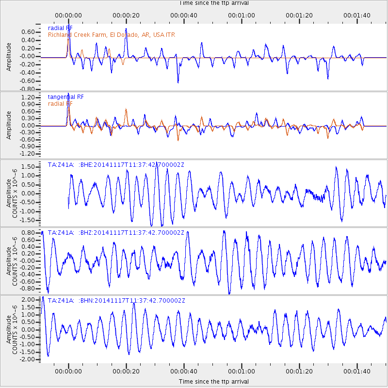
Z41A Richland Creek Farm, El Dorado, AR, USA - Earthquake Result Viewer
*The percent match for this event was below the threshold and hence no stack was calculated.
| Earthquake location: |
Southeast Of Easter Island |
| Earthquake latitude/longitude: |
-36.0/-102.2 |
| Earthquake time(UTC): |
2014/11/17 (321) 11:27:05 GMT |
| Earthquake Depth: |
10 km |
| Earthquake Magnitude: |
5.4 MW, 5.0 mb, 4.7 MS |
| Earthquake Catalog/Contributor: |
ISC/ISC |
|
| Network: |
TA USArray Transportable Network (new EarthScope stations) |
| Station: |
Z41A Richland Creek Farm, El Dorado, AR, USA |
| Lat/Lon: |
33.26 N/92.80 W |
| Elevation: |
62 m |
|
| Distance: |
69.4 deg |
| Az: |
8.446 deg |
| Baz: |
188.175 deg |
| Ray Param: |
$rayparam |
*The percent match for this event was below the threshold and hence was not used in the summary stack. |
|
| Radial Match: |
42.887432 % |
| Radial Bump: |
288 |
| Transverse Match: |
46.947495 % |
| Transverse Bump: |
400 |
| SOD ConfigId: |
3390531 |
| Insert Time: |
2019-04-15 01:36:32.688 +0000 |
| GWidth: |
2.5 |
| Max Bumps: |
400 |
| Tol: |
0.001 |
|
Signal To Noise
| Channel | StoN | STA | LTA |
| TA:Z41A: :BHZ:20141117T11:37:42.700002Z | 0.4823373 | 1.952165E-7 | 4.0473023E-7 |
| TA:Z41A: :BHN:20141117T11:37:42.700002Z | 0.37278688 | 3.667202E-7 | 9.837262E-7 |
| TA:Z41A: :BHE:20141117T11:37:42.700002Z | 1.87264 | 1.2166643E-6 | 6.497054E-7 |
| Arrivals |
| Ps | |
| PpPs | |
| PsPs/PpSs | |


