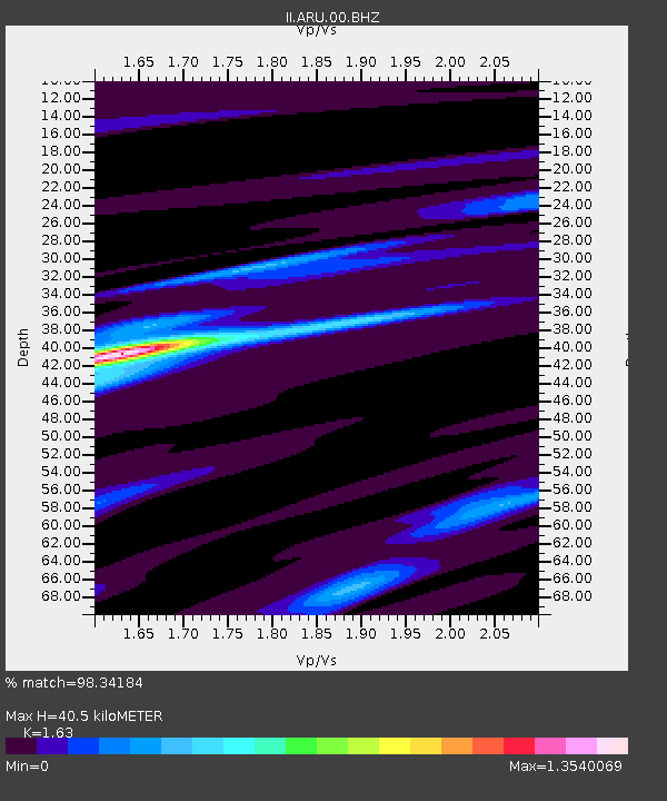
ARU Arti, Russia - Earthquake Result Viewer

Earthquake location: Irian Jaya Region, Indonesia
Earthquake latitude/longitude: -0.4/132.9
Earthquake time(UTC): 2009/01/03 (003) 19:43:50 GMT
Earthquake Depth: 17 km
Earthquake Magnitude: 6.6 MB, 7.5 MS, 7.6 MW, 7.6 MW
Earthquake Catalog/Contributor: WHDF/NEIC
Network: II Global Seismograph Network (GSN - IRIS/IDA)
Station: ARU Arti, Russia
Lat/Lon: 56.43 N/58.56 E
Elevation: 250 m
Distance: 81.7 deg
Az: 327.282 deg
Baz: 103.361 deg
Ray Param: 0.04738123
Estimated Moho Depth: 40.5 km
Estimated Crust Vp/Vs: 1.63
Assumed Crust Vp: 6.159 km/s
Estimated Crust Vs: 3.778 km/s
Estimated Crust Poisson's Ratio: 0.20
Radial Match: 98.34184 %
Radial Bump: 291
Transverse Match: 93.67613 %
Transverse Bump: 400
SOD ConfigId: 2834
Insert Time: 2010-03-01 16:36:48.165 +0000
GWidth: 2.5
Max Bumps: 400
Tol: 0.001

Signal To Noise

ChannelStoNSTALTA
II:ARU:00:BHN:20090103T19:55:36.696997Z3.67344216.874881E-71.8715095E-7
II:ARU:00:BHE:20090103T19:55:36.696997Z0.234543193.4377415E-81.465718E-7
II:ARU:00:BHZ:20090103T19:55:36.699011Z2.37595222.7445358E-71.1551309E-7
Arrivals
Ps4.3 SECOND
PpPs17 SECOND
PsPs/PpSs21 SECOND