You are here: Home > Network List > TA - USArray Transportable Network (new EarthScope stations) Stations List
> Station D41A Chassel, MI, USA > Earthquake Result Viewer
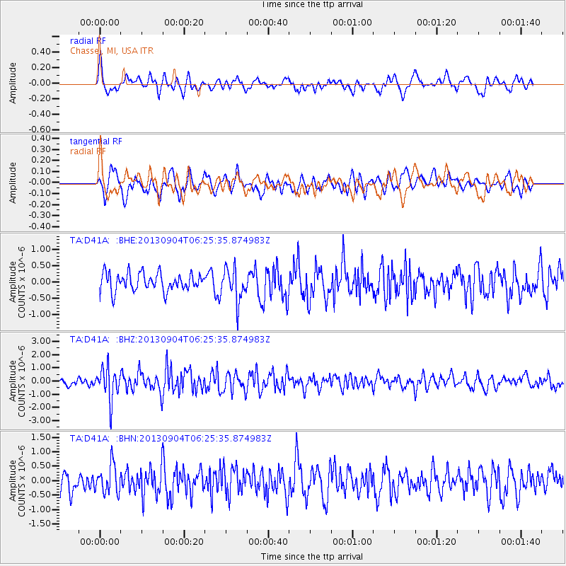
D41A Chassel, MI, USA - Earthquake Result Viewer
*The percent match for this event was below the threshold and hence no stack was calculated.
| Earthquake location: |
Andreanof Islands, Aleutian Is. |
| Earthquake latitude/longitude: |
51.6/-174.8 |
| Earthquake time(UTC): |
2013/09/04 (247) 06:16:49 GMT |
| Earthquake Depth: |
21 km |
| Earthquake Magnitude: |
5.7 MWW, 5.5 ML, 5.5 MI, 5.7 MWB, 5.7 MWW, 5.8 MWC |
| Earthquake Catalog/Contributor: |
NEIC PDE/NEIC COMCAT |
|
| Network: |
TA USArray Transportable Network (new EarthScope stations) |
| Station: |
D41A Chassel, MI, USA |
| Lat/Lon: |
47.06 N/88.57 W |
| Elevation: |
271 m |
|
| Distance: |
53.2 deg |
| Az: |
58.366 deg |
| Baz: |
308.996 deg |
| Ray Param: |
$rayparam |
*The percent match for this event was below the threshold and hence was not used in the summary stack. |
|
| Radial Match: |
71.63916 % |
| Radial Bump: |
400 |
| Transverse Match: |
61.789883 % |
| Transverse Bump: |
400 |
| SOD ConfigId: |
626651 |
| Insert Time: |
2014-04-18 11:17:02.172 +0000 |
| GWidth: |
2.5 |
| Max Bumps: |
400 |
| Tol: |
0.001 |
|
Signal To Noise
| Channel | StoN | STA | LTA |
| TA:D41A: :BHZ:20130904T06:25:35.874983Z | 4.2192955 | 1.2142202E-6 | 2.8777794E-7 |
| TA:D41A: :BHN:20130904T06:25:35.874983Z | 1.7360185 | 4.934326E-7 | 2.8423233E-7 |
| TA:D41A: :BHE:20130904T06:25:35.874983Z | 1.8930873 | 5.0986444E-7 | 2.6932963E-7 |
| Arrivals |
| Ps | |
| PpPs | |
| PsPs/PpSs | |


