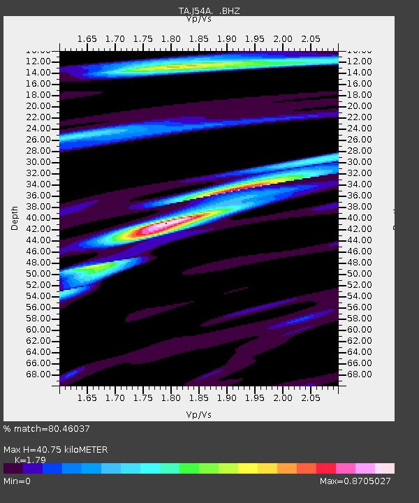
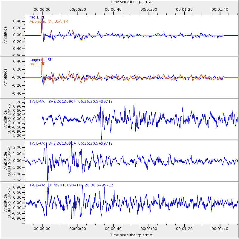
J54A Appleton, NY, USA - Earthquake Result Viewer

Earthquake location: Andreanof Islands, Aleutian Is.
Earthquake latitude/longitude: 51.6/-174.8
Earthquake time(UTC): 2013/09/04 (247) 06:16:49 GMT
Earthquake Depth: 21 km
Earthquake Magnitude: 5.7 MWW, 5.5 ML, 5.5 MI, 5.7 MWB, 5.7 MWW, 5.8 MWC
Earthquake Catalog/Contributor: NEIC PDE/NEIC COMCAT
Network: TA USArray Transportable Network (new EarthScope stations)
Station: J54A Appleton, NY, USA
Lat/Lon: 43.27 N/78.64 W
Elevation: 112 m
Distance: 61.0 deg
Az: 56.132 deg
Baz: 314.809 deg
Ray Param: 0.06113801
Estimated Moho Depth: 40.75 km
Estimated Crust Vp/Vs: 1.79
Assumed Crust Vp: 6.419 km/s
Estimated Crust Vs: 3.586 km/s
Estimated Crust Poisson's Ratio: 0.27
Radial Match: 80.46037 %
Radial Bump: 400
Transverse Match: 57.27656 %
Transverse Bump: 400
SOD ConfigId: 626651
Insert Time: 2014-04-18 11:20:39.320 +0000
GWidth: 2.5
Max Bumps: 400
Tol: 0.001

Signal To Noise

ChannelStoNSTALTA
TA:J54A: :BHZ:20130904T06:26:30.549971Z7.98319531.2597233E-61.5779688E-7
TA:J54A: :BHN:20130904T06:26:30.549971Z4.2874964.422088E-71.0313917E-7
TA:J54A: :BHE:20130904T06:26:30.549971Z3.17345215.400577E-71.7017987E-7
Arrivals
Ps5.2 SECOND
PpPs17 SECOND
PsPs/PpSs22 SECOND