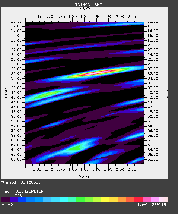
L40A Anamosa, IA, USA - Earthquake Result Viewer
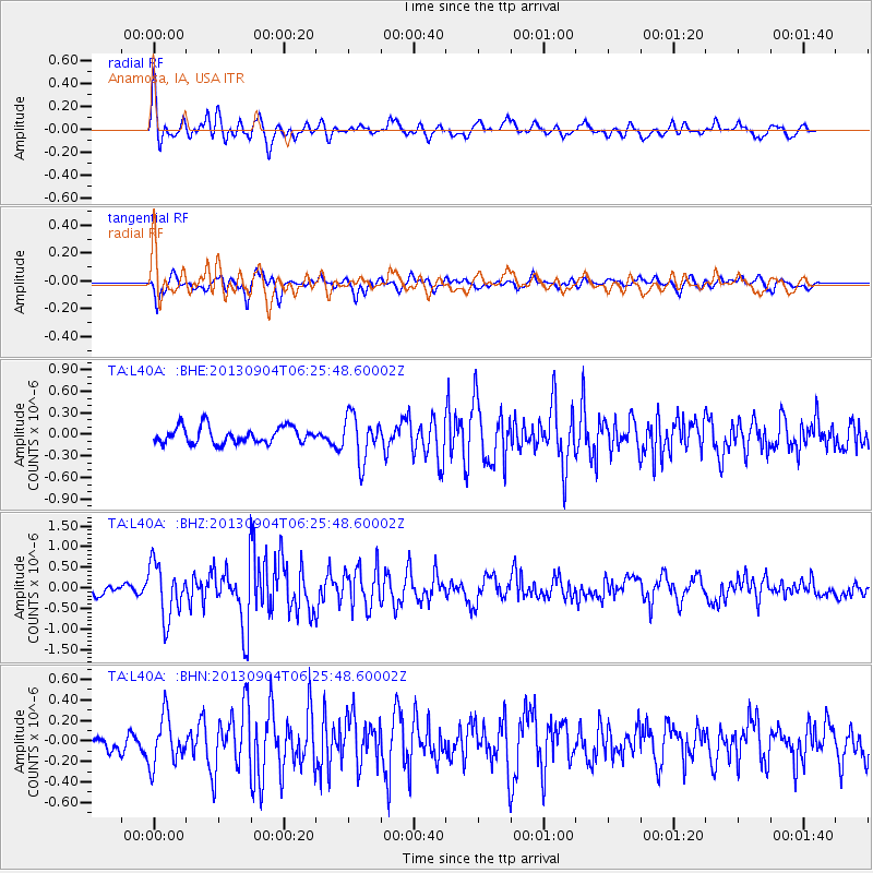
Earthquake location: Andreanof Islands, Aleutian Is.
Earthquake latitude/longitude: 51.6/-174.8
Earthquake time(UTC): 2013/09/04 (247) 06:16:49 GMT
Earthquake Depth: 21 km
Earthquake Magnitude: 5.7 MWW, 5.5 ML, 5.5 MI, 5.7 MWB, 5.7 MWW, 5.8 MWC
Earthquake Catalog/Contributor: NEIC PDE/NEIC COMCAT
Network: TA USArray Transportable Network (new EarthScope stations)
Station: L40A Anamosa, IA, USA
Lat/Lon: 42.06 N/91.22 W
Elevation: 242 m
Distance: 55.0 deg
Az: 64.6 deg
Baz: 310.793 deg
Ray Param: 0.06505765
Estimated Moho Depth: 31.5 km
Estimated Crust Vp/Vs: 1.89
Assumed Crust Vp: 6.53 km/s
Estimated Crust Vs: 3.446 km/s
Estimated Crust Poisson's Ratio: 0.31
Radial Match: 85.108055 %
Radial Bump: 400
Transverse Match: 61.03279 %
Transverse Bump: 400
SOD ConfigId: 626651
Insert Time: 2014-04-18 11:21:38.074 +0000
GWidth: 2.5
Max Bumps: 400
Tol: 0.001

Signal To Noise

ChannelStoNSTALTA
TA:L40A: :BHZ:20130904T06:25:48.60002Z4.55295566.511897E-71.430257E-7
TA:L40A: :BHN:20130904T06:25:48.60002Z1.62995282.386904E-71.4644007E-7
TA:L40A: :BHE:20130904T06:25:48.60002Z2.67696673.057726E-71.1422354E-7
Arrivals
Ps4.5 SECOND
PpPs13 SECOND
PsPs/PpSs18 SECOND