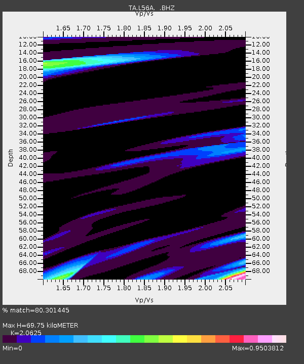
L56A Greenwood, NY, USA - Earthquake Result Viewer

Earthquake location: Andreanof Islands, Aleutian Is.
Earthquake latitude/longitude: 51.6/-174.8
Earthquake time(UTC): 2013/09/04 (247) 06:16:49 GMT
Earthquake Depth: 21 km
Earthquake Magnitude: 5.7 MWW, 5.5 ML, 5.5 MI, 5.7 MWB, 5.7 MWW, 5.8 MWC
Earthquake Catalog/Contributor: NEIC PDE/NEIC COMCAT
Network: TA USArray Transportable Network (new EarthScope stations)
Station: L56A Greenwood, NY, USA
Lat/Lon: 42.14 N/77.56 W
Elevation: 688 m
Distance: 62.4 deg
Az: 56.398 deg
Baz: 315.666 deg
Ray Param: 0.060250774
Estimated Moho Depth: 69.75 km
Estimated Crust Vp/Vs: 2.06
Assumed Crust Vp: 6.476 km/s
Estimated Crust Vs: 3.14 km/s
Estimated Crust Poisson's Ratio: 0.35
Radial Match: 80.301445 %
Radial Bump: 400
Transverse Match: 73.331406 %
Transverse Bump: 400
SOD ConfigId: 626651
Insert Time: 2014-04-18 11:22:03.112 +0000
GWidth: 2.5
Max Bumps: 400
Tol: 0.001

Signal To Noise

ChannelStoNSTALTA
TA:L56A: :BHZ:20130904T06:26:39.749983Z8.3556982.535329E-63.0342517E-7
TA:L56A: :BHN:20130904T06:26:39.749983Z3.0397835.9552576E-71.9591062E-7
TA:L56A: :BHE:20130904T06:26:39.749983Z3.50614576.9416905E-71.9798637E-7
Arrivals
Ps12 SECOND
PpPs32 SECOND
PsPs/PpSs44 SECOND