You are here: Home > Network List > TA - USArray Transportable Network (new EarthScope stations) Stations List
> Station M47A Cromwell, IN, USA > Earthquake Result Viewer
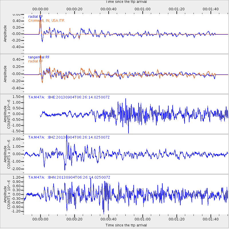
M47A Cromwell, IN, USA - Earthquake Result Viewer
*The percent match for this event was below the threshold and hence no stack was calculated.
| Earthquake location: |
Andreanof Islands, Aleutian Is. |
| Earthquake latitude/longitude: |
51.6/-174.8 |
| Earthquake time(UTC): |
2013/09/04 (247) 06:16:49 GMT |
| Earthquake Depth: |
21 km |
| Earthquake Magnitude: |
5.7 MWW, 5.5 ML, 5.5 MI, 5.7 MWB, 5.7 MWW, 5.8 MWC |
| Earthquake Catalog/Contributor: |
NEIC PDE/NEIC COMCAT |
|
| Network: |
TA USArray Transportable Network (new EarthScope stations) |
| Station: |
M47A Cromwell, IN, USA |
| Lat/Lon: |
41.36 N/85.62 W |
| Elevation: |
283 m |
|
| Distance: |
58.6 deg |
| Az: |
61.878 deg |
| Baz: |
313.016 deg |
| Ray Param: |
$rayparam |
*The percent match for this event was below the threshold and hence was not used in the summary stack. |
|
| Radial Match: |
77.24347 % |
| Radial Bump: |
400 |
| Transverse Match: |
68.54808 % |
| Transverse Bump: |
400 |
| SOD ConfigId: |
626651 |
| Insert Time: |
2014-04-18 11:22:20.635 +0000 |
| GWidth: |
2.5 |
| Max Bumps: |
400 |
| Tol: |
0.001 |
|
Signal To Noise
| Channel | StoN | STA | LTA |
| TA:M47A: :BHZ:20130904T06:26:14.025007Z | 4.098585 | 6.283074E-7 | 1.532986E-7 |
| TA:M47A: :BHN:20130904T06:26:14.025007Z | 1.8509868 | 2.5411427E-7 | 1.3728584E-7 |
| TA:M47A: :BHE:20130904T06:26:14.025007Z | 2.2030334 | 2.6809226E-7 | 1.2169232E-7 |
| Arrivals |
| Ps | |
| PpPs | |
| PsPs/PpSs | |


