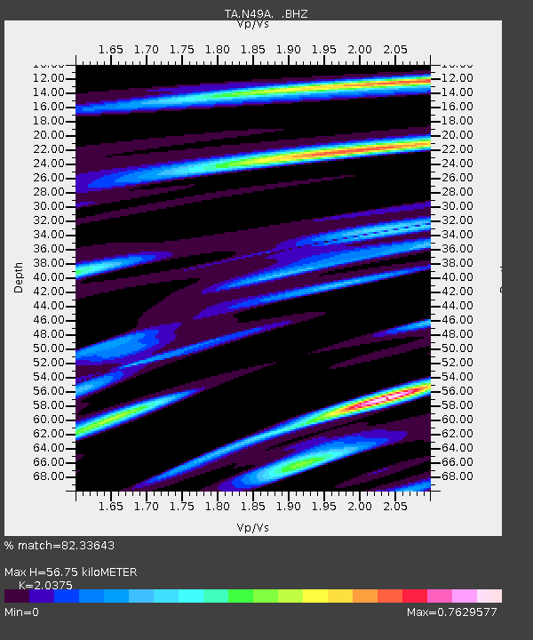
N49A Columbus Grove, OH, USA - Earthquake Result Viewer
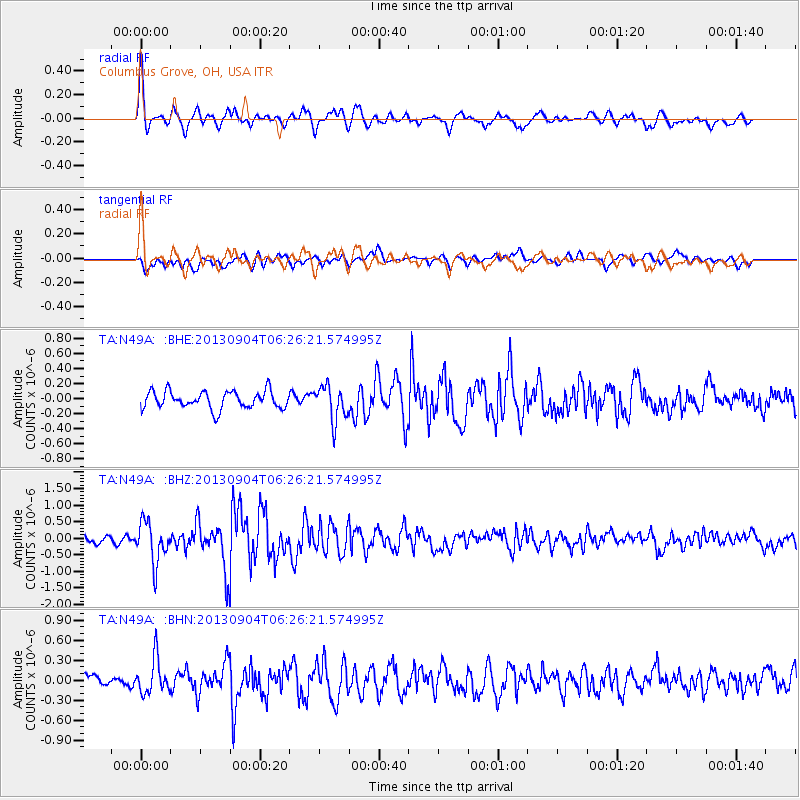
Earthquake location: Andreanof Islands, Aleutian Is.
Earthquake latitude/longitude: 51.6/-174.8
Earthquake time(UTC): 2013/09/04 (247) 06:16:49 GMT
Earthquake Depth: 21 km
Earthquake Magnitude: 5.7 MWW, 5.5 ML, 5.5 MI, 5.7 MWB, 5.7 MWW, 5.8 MWC
Earthquake Catalog/Contributor: NEIC PDE/NEIC COMCAT
Network: TA USArray Transportable Network (new EarthScope stations)
Station: N49A Columbus Grove, OH, USA
Lat/Lon: 40.92 N/84.18 W
Elevation: 225 m
Distance: 59.7 deg
Az: 61.379 deg
Baz: 313.703 deg
Ray Param: 0.06200449
Estimated Moho Depth: 56.75 km
Estimated Crust Vp/Vs: 2.04
Assumed Crust Vp: 6.498 km/s
Estimated Crust Vs: 3.189 km/s
Estimated Crust Poisson's Ratio: 0.34
Radial Match: 82.33643 %
Radial Bump: 400
Transverse Match: 60.516434 %
Transverse Bump: 400
SOD ConfigId: 626651
Insert Time: 2014-04-18 11:23:13.522 +0000
GWidth: 2.5
Max Bumps: 400
Tol: 0.001

Signal To Noise

ChannelStoNSTALTA
TA:N49A: :BHZ:20130904T06:26:21.574995Z6.16143276.1835163E-71.0035842E-7
TA:N49A: :BHN:20130904T06:26:21.574995Z2.78527952.642525E-79.487468E-8
TA:N49A: :BHE:20130904T06:26:21.574995Z2.01559852.3097203E-71.1459228E-7
Arrivals
Ps9.5 SECOND
PpPs25 SECOND
PsPs/PpSs35 SECOND