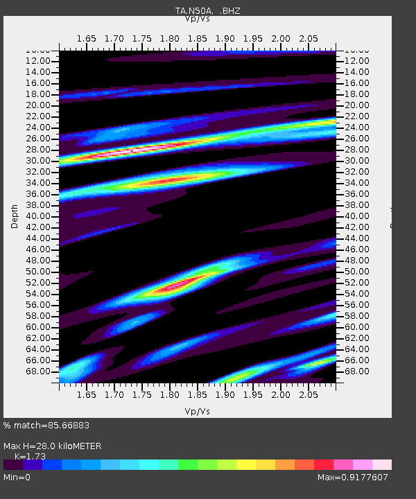
N50A Nevada, OH, USA - Earthquake Result Viewer
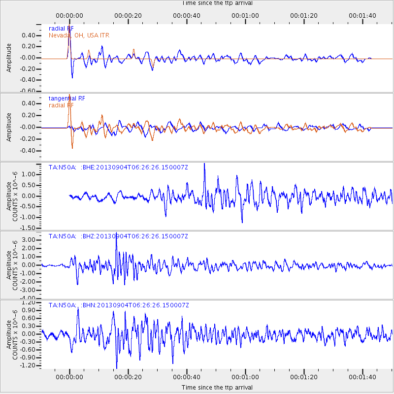
Earthquake location: Andreanof Islands, Aleutian Is.
Earthquake latitude/longitude: 51.6/-174.8
Earthquake time(UTC): 2013/09/04 (247) 06:16:49 GMT
Earthquake Depth: 21 km
Earthquake Magnitude: 5.7 MWW, 5.5 ML, 5.5 MI, 5.7 MWB, 5.7 MWW, 5.8 MWC
Earthquake Catalog/Contributor: NEIC PDE/NEIC COMCAT
Network: TA USArray Transportable Network (new EarthScope stations)
Station: N50A Nevada, OH, USA
Lat/Lon: 40.77 N/83.15 W
Elevation: 277 m
Distance: 60.3 deg
Az: 60.877 deg
Baz: 314.125 deg
Ray Param: 0.06156638
Estimated Moho Depth: 28.0 km
Estimated Crust Vp/Vs: 1.73
Assumed Crust Vp: 6.498 km/s
Estimated Crust Vs: 3.756 km/s
Estimated Crust Poisson's Ratio: 0.25
Radial Match: 85.66883 %
Radial Bump: 400
Transverse Match: 51.4992 %
Transverse Bump: 400
SOD ConfigId: 626651
Insert Time: 2014-04-18 11:23:16.063 +0000
GWidth: 2.5
Max Bumps: 400
Tol: 0.001

Signal To Noise

ChannelStoNSTALTA
TA:N50A: :BHZ:20130904T06:26:26.150007Z5.9096767.897139E-71.3363066E-7
TA:N50A: :BHN:20130904T06:26:26.150007Z3.08113073.897276E-71.264885E-7
TA:N50A: :BHE:20130904T06:26:26.150007Z2.8803283.3110956E-71.14955505E-7
Arrivals
Ps3.3 SECOND
PpPs11 SECOND
PsPs/PpSs15 SECOND