N60A Cedar Hill Farm, Mount Bethel, PA, USA - Earthquake Result Viewer
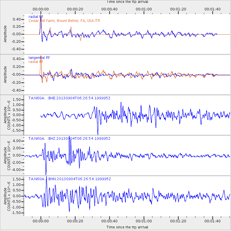
Earthquake location: Andreanof Islands, Aleutian Is.
Earthquake latitude/longitude: 51.6/-174.8
Earthquake time(UTC): 2013/09/04 (247) 06:16:49 GMT
Earthquake Depth: 21 km
Earthquake Magnitude: 5.7 MWW, 5.5 ML, 5.5 MI, 5.7 MWB, 5.7 MWW, 5.8 MWC
Earthquake Catalog/Contributor: NEIC PDE/NEIC COMCAT
Network: TA USArray Transportable Network (new EarthScope stations)
Station: N60A Cedar Hill Farm, Mount Bethel, PA, USA
Lat/Lon: 40.87 N/75.10 W
Elevation: 189 m
Distance: 64.6 deg
Az: 55.879 deg
Baz: 317.057 deg
Ray Param: 0.05882471
Estimated Moho Depth: 40.25 km
Estimated Crust Vp/Vs: 1.79
Assumed Crust Vp: 6.283 km/s
Estimated Crust Vs: 3.505 km/s
Estimated Crust Poisson's Ratio: 0.27
Radial Match: 80.5078 %
Radial Bump: 400
Transverse Match: 71.97412 %
Transverse Bump: 400
SOD ConfigId: 626651
Insert Time: 2014-04-18 11:23:39.288 +0000
GWidth: 2.5
Max Bumps: 400
Tol: 0.001

Signal To Noise

ChannelStoNSTALTA
TA:N60A: :BHZ:20130904T06:26:54.199995Z7.56846051.6078594E-62.1244207E-7
TA:N60A: :BHN:20130904T06:26:54.199995Z4.4120486.279444E-71.4232494E-7
TA:N60A: :BHE:20130904T06:26:54.199995Z4.23012456.475485E-71.5308025E-7
Arrivals
Ps5.3 SECOND
PpPs17 SECOND
PsPs/PpSs22 SECOND