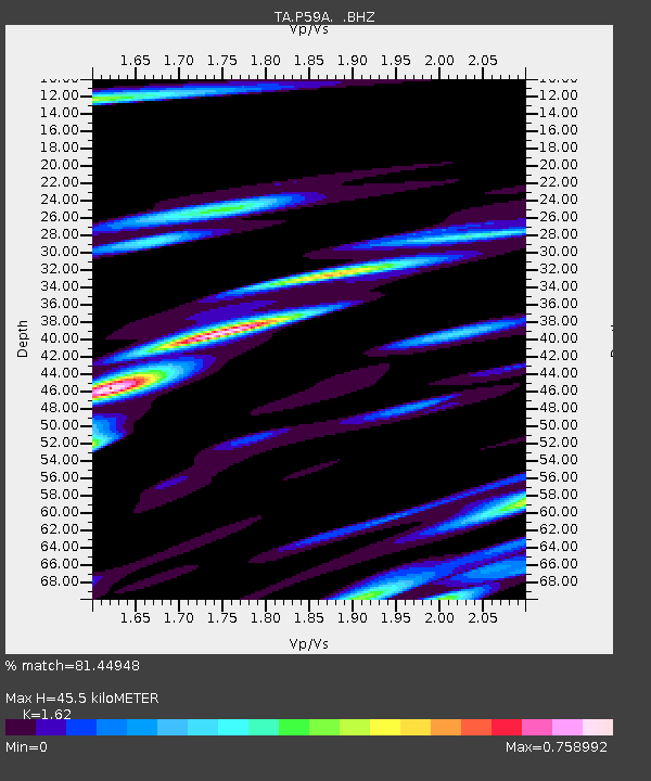
P59A Jarrettsville, MD, USA - Earthquake Result Viewer

Earthquake location: Andreanof Islands, Aleutian Is.
Earthquake latitude/longitude: 51.6/-174.8
Earthquake time(UTC): 2013/09/04 (247) 06:16:49 GMT
Earthquake Depth: 21 km
Earthquake Magnitude: 5.7 MWW, 5.5 ML, 5.5 MI, 5.7 MWB, 5.7 MWW, 5.8 MWC
Earthquake Catalog/Contributor: NEIC PDE/NEIC COMCAT
Network: TA USArray Transportable Network (new EarthScope stations)
Station: P59A Jarrettsville, MD, USA
Lat/Lon: 39.61 N/76.43 W
Elevation: 157 m
Distance: 64.8 deg
Az: 57.655 deg
Baz: 316.96 deg
Ray Param: 0.058680672
Estimated Moho Depth: 45.5 km
Estimated Crust Vp/Vs: 1.62
Assumed Crust Vp: 6.419 km/s
Estimated Crust Vs: 3.962 km/s
Estimated Crust Poisson's Ratio: 0.19
Radial Match: 81.44948 %
Radial Bump: 400
Transverse Match: 61.419388 %
Transverse Bump: 400
SOD ConfigId: 626651
Insert Time: 2014-04-18 11:24:48.329 +0000
GWidth: 2.5
Max Bumps: 400
Tol: 0.001

Signal To Noise

ChannelStoNSTALTA
TA:P59A: :BHZ:20130904T06:26:55.674971Z5.32772641.0450502E-61.9615314E-7
TA:P59A: :BHN:20130904T06:26:55.674971Z2.97248823.305902E-71.1121667E-7
TA:P59A: :BHE:20130904T06:26:55.674971Z2.6877814.0511824E-71.507259E-7
Arrivals
Ps4.6 SECOND
PpPs18 SECOND
PsPs/PpSs22 SECOND