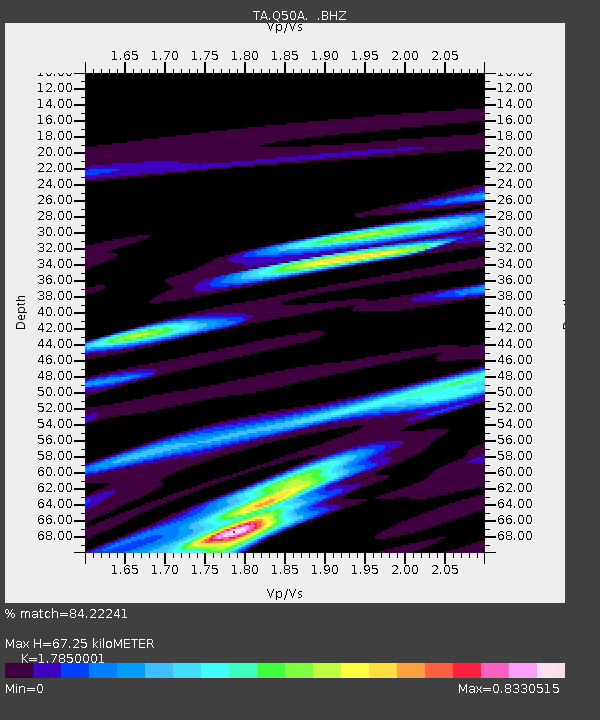
Q50A Georgetown, OH, USA - Earthquake Result Viewer

Earthquake location: Andreanof Islands, Aleutian Is.
Earthquake latitude/longitude: 51.6/-174.8
Earthquake time(UTC): 2013/09/04 (247) 06:16:49 GMT
Earthquake Depth: 21 km
Earthquake Magnitude: 5.7 MWW, 5.5 ML, 5.5 MI, 5.7 MWB, 5.7 MWW, 5.8 MWC
Earthquake Catalog/Contributor: NEIC PDE/NEIC COMCAT
Network: TA USArray Transportable Network (new EarthScope stations)
Station: Q50A Georgetown, OH, USA
Lat/Lon: 38.84 N/83.98 W
Elevation: 262 m
Distance: 61.2 deg
Az: 62.966 deg
Baz: 314.615 deg
Ray Param: 0.060978793
Estimated Moho Depth: 67.25 km
Estimated Crust Vp/Vs: 1.79
Assumed Crust Vp: 6.232 km/s
Estimated Crust Vs: 3.491 km/s
Estimated Crust Poisson's Ratio: 0.27
Radial Match: 84.22241 %
Radial Bump: 359
Transverse Match: 64.831924 %
Transverse Bump: 400
SOD ConfigId: 626651
Insert Time: 2014-04-18 11:25:01.367 +0000
GWidth: 2.5
Max Bumps: 400
Tol: 0.001

Signal To Noise

ChannelStoNSTALTA
TA:Q50A: :BHZ:20130904T06:26:32.199995Z6.4386087.579971E-71.17726856E-7
TA:Q50A: :BHN:20130904T06:26:32.199995Z3.18767952.4290173E-77.620017E-8
TA:Q50A: :BHE:20130904T06:26:32.199995Z2.34194063.0297008E-71.2936711E-7
Arrivals
Ps8.8 SECOND
PpPs29 SECOND
PsPs/PpSs38 SECOND