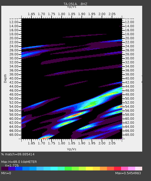
Q51A Peebles, OH, USA - Earthquake Result Viewer

Earthquake location: Andreanof Islands, Aleutian Is.
Earthquake latitude/longitude: 51.6/-174.8
Earthquake time(UTC): 2013/09/04 (247) 06:16:49 GMT
Earthquake Depth: 21 km
Earthquake Magnitude: 5.7 MWW, 5.5 ML, 5.5 MI, 5.7 MWB, 5.7 MWW, 5.8 MWC
Earthquake Catalog/Contributor: NEIC PDE/NEIC COMCAT
Network: TA USArray Transportable Network (new EarthScope stations)
Station: Q51A Peebles, OH, USA
Lat/Lon: 39.03 N/83.35 W
Elevation: 362 m
Distance: 61.5 deg
Az: 62.422 deg
Baz: 314.751 deg
Ray Param: 0.060834836
Estimated Moho Depth: 69.0 km
Estimated Crust Vp/Vs: 1.73
Assumed Crust Vp: 6.232 km/s
Estimated Crust Vs: 3.613 km/s
Estimated Crust Poisson's Ratio: 0.25
Radial Match: 89.885414 %
Radial Bump: 400
Transverse Match: 78.38725 %
Transverse Bump: 400
SOD ConfigId: 626651
Insert Time: 2014-04-18 11:25:03.705 +0000
GWidth: 2.5
Max Bumps: 400
Tol: 0.001

Signal To Noise

ChannelStoNSTALTA
TA:Q51A: :BHZ:20130904T06:26:33.699995Z7.5945448.577392E-71.1294151E-7
TA:Q51A: :BHN:20130904T06:26:33.699995Z3.81484754.292715E-71.12526514E-7
TA:Q51A: :BHE:20130904T06:26:33.699995Z3.91093874.0235514E-71.02879426E-7
Arrivals
Ps8.4 SECOND
PpPs29 SECOND
PsPs/PpSs37 SECOND