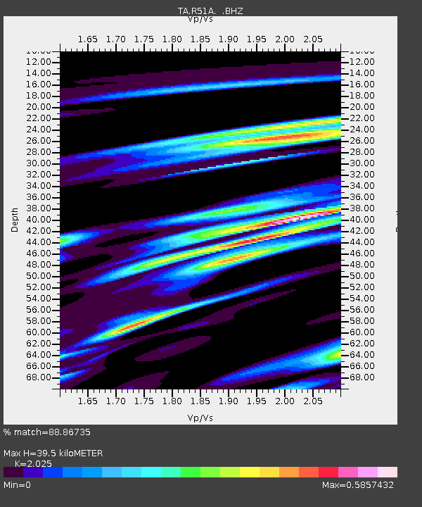
R51A Hillsboro, KY, USA - Earthquake Result Viewer

Earthquake location: Andreanof Islands, Aleutian Is.
Earthquake latitude/longitude: 51.6/-174.8
Earthquake time(UTC): 2013/09/04 (247) 06:16:49 GMT
Earthquake Depth: 21 km
Earthquake Magnitude: 5.7 MWW, 5.5 ML, 5.5 MI, 5.7 MWB, 5.7 MWW, 5.8 MWC
Earthquake Catalog/Contributor: NEIC PDE/NEIC COMCAT
Network: TA USArray Transportable Network (new EarthScope stations)
Station: R51A Hillsboro, KY, USA
Lat/Lon: 38.30 N/83.58 W
Elevation: 231 m
Distance: 61.8 deg
Az: 63.155 deg
Baz: 314.951 deg
Ray Param: 0.060594697
Estimated Moho Depth: 39.5 km
Estimated Crust Vp/Vs: 2.03
Assumed Crust Vp: 6.232 km/s
Estimated Crust Vs: 3.077 km/s
Estimated Crust Poisson's Ratio: 0.34
Radial Match: 88.86735 %
Radial Bump: 400
Transverse Match: 66.40082 %
Transverse Bump: 400
SOD ConfigId: 626651
Insert Time: 2014-04-18 11:25:35.165 +0000
GWidth: 2.5
Max Bumps: 400
Tol: 0.001

Signal To Noise

ChannelStoNSTALTA
TA:R51A: :BHZ:20130904T06:26:36.249983Z8.5448639.790247E-71.1457465E-7
TA:R51A: :BHN:20130904T06:26:36.249983Z4.6517943.9533717E-78.4985956E-8
TA:R51A: :BHE:20130904T06:26:36.249983Z3.58856373.8608974E-71.0758893E-7
Arrivals
Ps6.7 SECOND
PpPs18 SECOND
PsPs/PpSs25 SECOND