R58B Mineral, VA, USA - Earthquake Result Viewer
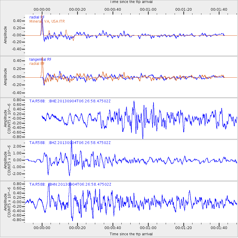
Earthquake location: Andreanof Islands, Aleutian Is.
Earthquake latitude/longitude: 51.6/-174.8
Earthquake time(UTC): 2013/09/04 (247) 06:16:49 GMT
Earthquake Depth: 21 km
Earthquake Magnitude: 5.7 MWW, 5.5 ML, 5.5 MI, 5.7 MWB, 5.7 MWW, 5.8 MWC
Earthquake Catalog/Contributor: NEIC PDE/NEIC COMCAT
Network: TA USArray Transportable Network (new EarthScope stations)
Station: R58B Mineral, VA, USA
Lat/Lon: 37.96 N/77.88 W
Elevation: 116 m
Distance: 65.2 deg
Az: 59.804 deg
Baz: 316.966 deg
Ray Param: 0.058398556
Estimated Moho Depth: 59.25 km
Estimated Crust Vp/Vs: 1.76
Assumed Crust Vp: 6.565 km/s
Estimated Crust Vs: 3.735 km/s
Estimated Crust Poisson's Ratio: 0.26
Radial Match: 82.22074 %
Radial Bump: 400
Transverse Match: 66.394424 %
Transverse Bump: 400
SOD ConfigId: 626651
Insert Time: 2014-04-18 11:25:54.165 +0000
GWidth: 2.5
Max Bumps: 400
Tol: 0.001

Signal To Noise

ChannelStoNSTALTA
TA:R58B: :BHZ:20130904T06:26:58.47502Z6.40425358.1764085E-71.2767153E-7
TA:R58B: :BHN:20130904T06:26:58.47502Z3.20704083.535274E-71.1023477E-7
TA:R58B: :BHE:20130904T06:26:58.47502Z1.42597191.8965453E-71.3300019E-7
Arrivals
Ps7.1 SECOND
PpPs24 SECOND
PsPs/PpSs31 SECOND