You are here: Home > Network List > TA - USArray Transportable Network (new EarthScope stations) Stations List
> Station G03D McMinnville, OR, USA > Earthquake Result Viewer
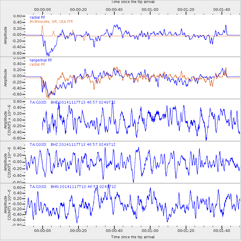
G03D McMinnville, OR, USA - Earthquake Result Viewer
*The percent match for this event was below the threshold and hence no stack was calculated.
| Earthquake location: |
Philippine Islands Region |
| Earthquake latitude/longitude: |
19.5/120.3 |
| Earthquake time(UTC): |
2014/11/17 (321) 13:34:14 GMT |
| Earthquake Depth: |
23 km |
| Earthquake Magnitude: |
5.0 MW, 5.1 mb, 4.6 MS |
| Earthquake Catalog/Contributor: |
ISC/ISC |
|
| Network: |
TA USArray Transportable Network (new EarthScope stations) |
| Station: |
G03D McMinnville, OR, USA |
| Lat/Lon: |
45.21 N/123.26 W |
| Elevation: |
222 m |
|
| Distance: |
93.5 deg |
| Az: |
39.377 deg |
| Baz: |
302.15 deg |
| Ray Param: |
$rayparam |
*The percent match for this event was below the threshold and hence was not used in the summary stack. |
|
| Radial Match: |
46.5951 % |
| Radial Bump: |
400 |
| Transverse Match: |
38.685658 % |
| Transverse Bump: |
400 |
| SOD ConfigId: |
3390531 |
| Insert Time: |
2019-04-15 01:47:43.856 +0000 |
| GWidth: |
2.5 |
| Max Bumps: |
400 |
| Tol: |
0.001 |
|
Signal To Noise
| Channel | StoN | STA | LTA |
| TA:G03D: :BHZ:20141117T13:46:57.024971Z | 1.3146698 | 2.5395846E-7 | 1.9317281E-7 |
| TA:G03D: :BHN:20141117T13:46:57.024971Z | 1.8953604 | 4.2008193E-7 | 2.2163697E-7 |
| TA:G03D: :BHE:20141117T13:46:57.024971Z | 1.0263182 | 2.3355646E-7 | 2.275673E-7 |
| Arrivals |
| Ps | |
| PpPs | |
| PsPs/PpSs | |


