You are here: Home > Network List > TA - USArray Transportable Network (new EarthScope stations) Stations List
> Station S49A Springfield, KY, USA > Earthquake Result Viewer
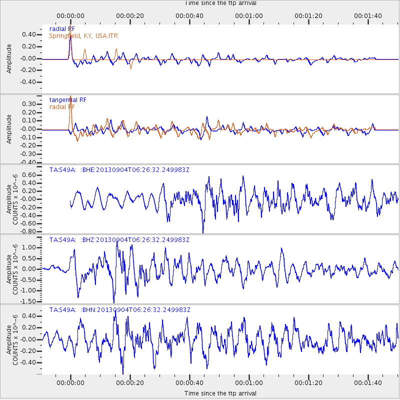
S49A Springfield, KY, USA - Earthquake Result Viewer
*The percent match for this event was below the threshold and hence no stack was calculated.
| Earthquake location: |
Andreanof Islands, Aleutian Is. |
| Earthquake latitude/longitude: |
51.6/-174.8 |
| Earthquake time(UTC): |
2013/09/04 (247) 06:16:49 GMT |
| Earthquake Depth: |
21 km |
| Earthquake Magnitude: |
5.7 MWW, 5.5 ML, 5.5 MI, 5.7 MWB, 5.7 MWW, 5.8 MWC |
| Earthquake Catalog/Contributor: |
NEIC PDE/NEIC COMCAT |
|
| Network: |
TA USArray Transportable Network (new EarthScope stations) |
| Station: |
S49A Springfield, KY, USA |
| Lat/Lon: |
37.78 N/85.29 W |
| Elevation: |
230 m |
|
| Distance: |
61.2 deg |
| Az: |
64.649 deg |
| Baz: |
314.617 deg |
| Ray Param: |
$rayparam |
*The percent match for this event was below the threshold and hence was not used in the summary stack. |
|
| Radial Match: |
68.5918 % |
| Radial Bump: |
370 |
| Transverse Match: |
64.08006 % |
| Transverse Bump: |
351 |
| SOD ConfigId: |
626651 |
| Insert Time: |
2014-04-18 11:26:06.722 +0000 |
| GWidth: |
2.5 |
| Max Bumps: |
400 |
| Tol: |
0.001 |
|
Signal To Noise
| Channel | StoN | STA | LTA |
| TA:S49A: :BHZ:20130904T06:26:32.249983Z | 4.611506 | 6.3843106E-7 | 1.3844307E-7 |
| TA:S49A: :BHN:20130904T06:26:32.249983Z | 1.877666 | 1.8716551E-7 | 9.967987E-8 |
| TA:S49A: :BHE:20130904T06:26:32.249983Z | 2.0528777 | 2.7792632E-7 | 1.3538377E-7 |
| Arrivals |
| Ps | |
| PpPs | |
| PsPs/PpSs | |


