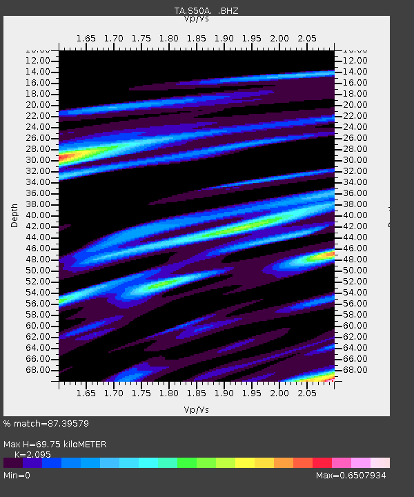
S50A Richmond, KY, USA - Earthquake Result Viewer

Earthquake location: Andreanof Islands, Aleutian Is.
Earthquake latitude/longitude: 51.6/-174.8
Earthquake time(UTC): 2013/09/04 (247) 06:16:49 GMT
Earthquake Depth: 21 km
Earthquake Magnitude: 5.7 MWW, 5.5 ML, 5.5 MI, 5.7 MWB, 5.7 MWW, 5.8 MWC
Earthquake Catalog/Contributor: NEIC PDE/NEIC COMCAT
Network: TA USArray Transportable Network (new EarthScope stations)
Station: S50A Richmond, KY, USA
Lat/Lon: 37.68 N/84.40 W
Elevation: 300 m
Distance: 61.8 deg
Az: 64.17 deg
Baz: 314.93 deg
Ray Param: 0.060606655
Estimated Moho Depth: 69.75 km
Estimated Crust Vp/Vs: 2.10
Assumed Crust Vp: 6.476 km/s
Estimated Crust Vs: 3.091 km/s
Estimated Crust Poisson's Ratio: 0.35
Radial Match: 87.39579 %
Radial Bump: 400
Transverse Match: 79.00039 %
Transverse Bump: 400
SOD ConfigId: 626651
Insert Time: 2014-04-18 11:26:08.199 +0000
GWidth: 2.5
Max Bumps: 400
Tol: 0.001

Signal To Noise

ChannelStoNSTALTA
TA:S50A: :BHZ:20130904T06:26:36.124983Z4.6500665.510216E-71.1849759E-7
TA:S50A: :BHN:20130904T06:26:36.124983Z3.17196542.1136015E-76.663381E-8
TA:S50A: :BHE:20130904T06:26:36.124983Z2.8593521.9784711E-76.9192986E-8
Arrivals
Ps12 SECOND
PpPs32 SECOND
PsPs/PpSs44 SECOND