You are here: Home > Network List > TJ - Tajikistan National Seismic Network Stations List
> Station GARM Garm, Tajikistan > Earthquake Result Viewer
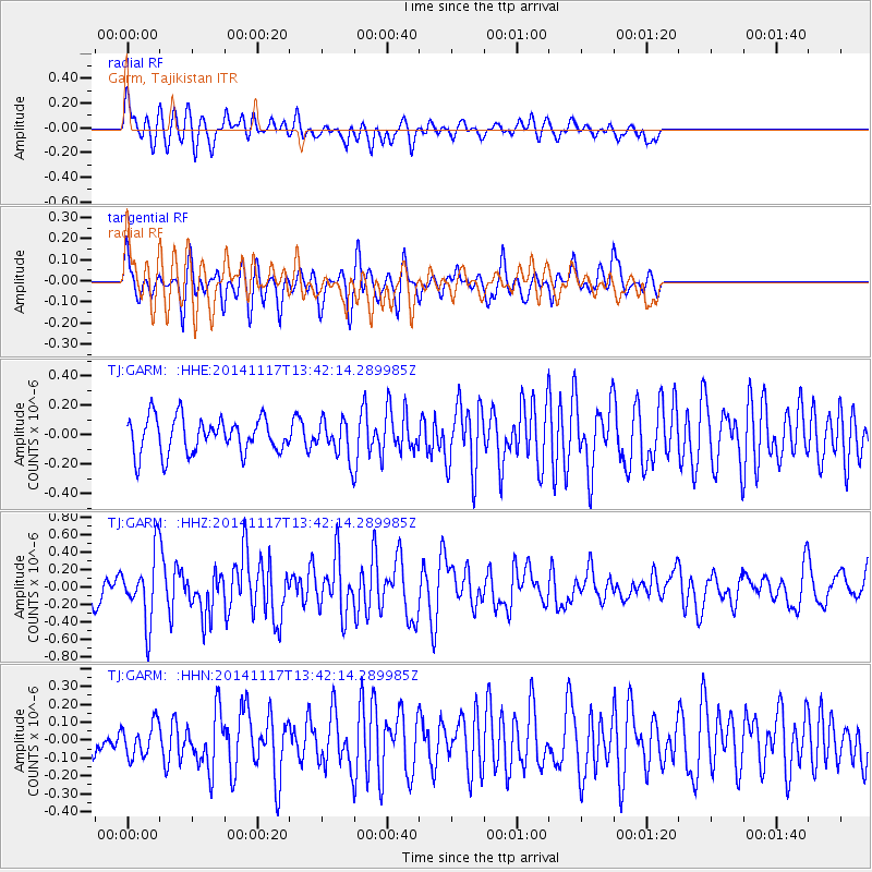
GARM Garm, Tajikistan - Earthquake Result Viewer
*The percent match for this event was below the threshold and hence no stack was calculated.
| Earthquake location: |
Philippine Islands Region |
| Earthquake latitude/longitude: |
19.5/120.3 |
| Earthquake time(UTC): |
2014/11/17 (321) 13:34:14 GMT |
| Earthquake Depth: |
23 km |
| Earthquake Magnitude: |
5.0 MW, 5.1 mb, 4.6 MS |
| Earthquake Catalog/Contributor: |
ISC/ISC |
|
| Network: |
TJ Tajikistan National Seismic Network |
| Station: |
GARM Garm, Tajikistan |
| Lat/Lon: |
39.00 N/70.32 E |
| Elevation: |
1305 m |
|
| Distance: |
47.1 deg |
| Az: |
305.449 deg |
| Baz: |
99.519 deg |
| Ray Param: |
$rayparam |
*The percent match for this event was below the threshold and hence was not used in the summary stack. |
|
| Radial Match: |
58.013065 % |
| Radial Bump: |
400 |
| Transverse Match: |
66.82155 % |
| Transverse Bump: |
400 |
| SOD ConfigId: |
3390531 |
| Insert Time: |
2019-04-15 01:47:51.525 +0000 |
| GWidth: |
2.5 |
| Max Bumps: |
400 |
| Tol: |
0.001 |
|
Signal To Noise
| Channel | StoN | STA | LTA |
| TJ:GARM: :HHZ:20141117T13:42:14.289985Z | 2.7236662 | 3.7376296E-7 | 1.3722789E-7 |
| TJ:GARM: :HHN:20141117T13:42:14.289985Z | 1.1470878 | 9.2241315E-8 | 8.041347E-8 |
| TJ:GARM: :HHE:20141117T13:42:14.289985Z | 1.0267245 | 1.2437313E-7 | 1.2113584E-7 |
| Arrivals |
| Ps | |
| PpPs | |
| PsPs/PpSs | |


