You are here: Home > Network List > UW - Pacific Northwest Regional Seismic Network Stations List
> Station HOOD Mt Hood Meadows, OR CREST BB SMO > Earthquake Result Viewer
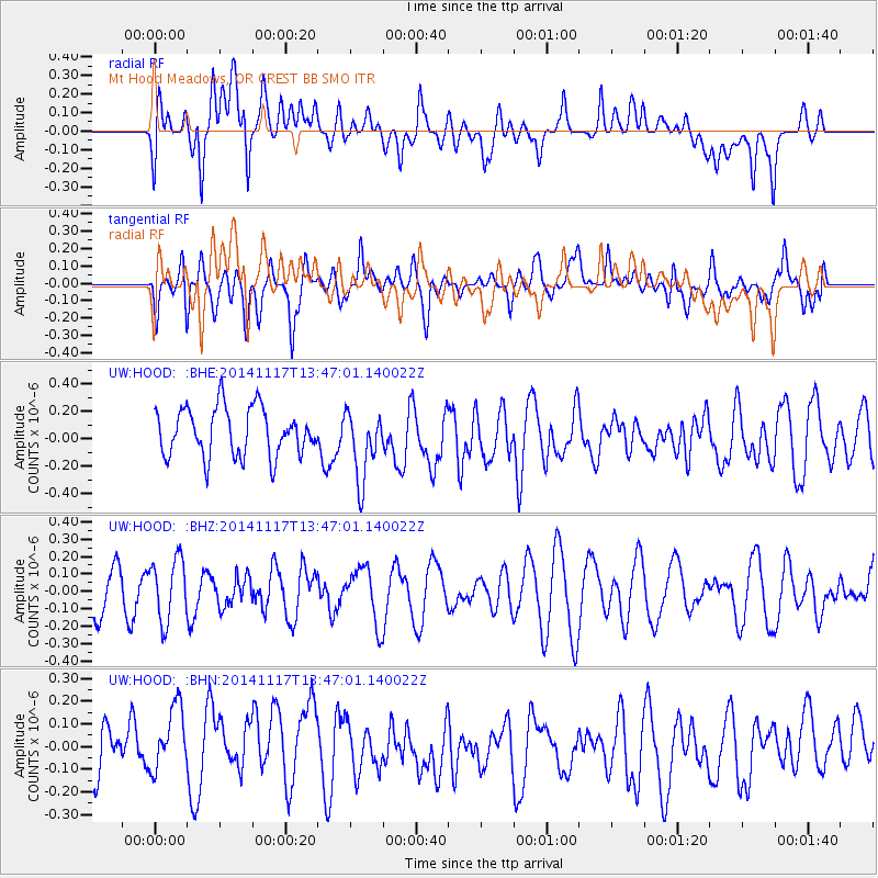
HOOD Mt Hood Meadows, OR CREST BB SMO - Earthquake Result Viewer
*The percent match for this event was below the threshold and hence no stack was calculated.
| Earthquake location: |
Philippine Islands Region |
| Earthquake latitude/longitude: |
19.5/120.3 |
| Earthquake time(UTC): |
2014/11/17 (321) 13:34:14 GMT |
| Earthquake Depth: |
23 km |
| Earthquake Magnitude: |
5.0 MW, 5.1 mb, 4.6 MS |
| Earthquake Catalog/Contributor: |
ISC/ISC |
|
| Network: |
UW Pacific Northwest Regional Seismic Network |
| Station: |
HOOD Mt Hood Meadows, OR CREST BB SMO |
| Lat/Lon: |
45.32 N/121.65 W |
| Elevation: |
1520 m |
|
| Distance: |
94.4 deg |
| Az: |
38.668 deg |
| Baz: |
303.34 deg |
| Ray Param: |
$rayparam |
*The percent match for this event was below the threshold and hence was not used in the summary stack. |
|
| Radial Match: |
52.88294 % |
| Radial Bump: |
400 |
| Transverse Match: |
56.917847 % |
| Transverse Bump: |
400 |
| SOD ConfigId: |
3390531 |
| Insert Time: |
2019-04-15 01:47:59.237 +0000 |
| GWidth: |
2.5 |
| Max Bumps: |
400 |
| Tol: |
0.001 |
|
Signal To Noise
| Channel | StoN | STA | LTA |
| UW:HOOD: :BHZ:20141117T13:47:01.140022Z | 1.4428397 | 1.7853952E-7 | 1.2374176E-7 |
| UW:HOOD: :BHN:20141117T13:47:01.140022Z | 1.2061555 | 1.6519355E-7 | 1.3695875E-7 |
| UW:HOOD: :BHE:20141117T13:47:01.140022Z | 1.4300442 | 2.493673E-7 | 1.7437733E-7 |
| Arrivals |
| Ps | |
| PpPs | |
| PsPs/PpSs | |


