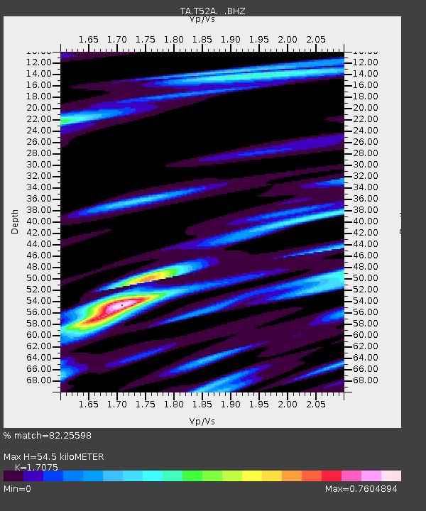
T52A Hallie, KY, USA - Earthquake Result Viewer

Earthquake location: Andreanof Islands, Aleutian Is.
Earthquake latitude/longitude: 51.6/-174.8
Earthquake time(UTC): 2013/09/04 (247) 06:16:49 GMT
Earthquake Depth: 21 km
Earthquake Magnitude: 5.7 MWW, 5.5 ML, 5.5 MI, 5.7 MWB, 5.7 MWW, 5.8 MWC
Earthquake Catalog/Contributor: NEIC PDE/NEIC COMCAT
Network: TA USArray Transportable Network (new EarthScope stations)
Station: T52A Hallie, KY, USA
Lat/Lon: 37.11 N/82.99 W
Elevation: 436 m
Distance: 63.0 deg
Az: 63.72 deg
Baz: 315.577 deg
Ray Param: 0.059824042
Estimated Moho Depth: 54.5 km
Estimated Crust Vp/Vs: 1.71
Assumed Crust Vp: 6.476 km/s
Estimated Crust Vs: 3.793 km/s
Estimated Crust Poisson's Ratio: 0.24
Radial Match: 82.25598 %
Radial Bump: 400
Transverse Match: 68.08586 %
Transverse Bump: 400
SOD ConfigId: 626651
Insert Time: 2014-04-18 11:26:54.252 +0000
GWidth: 2.5
Max Bumps: 400
Tol: 0.001

Signal To Noise

ChannelStoNSTALTA
TA:T52A: :BHZ:20130904T06:26:44.124983Z6.58179247.1408596E-71.0849415E-7
TA:T52A: :BHN:20130904T06:26:44.124983Z2.24455552.5649356E-71.1427365E-7
TA:T52A: :BHE:20130904T06:26:44.124983Z1.72578722.2692493E-71.3149068E-7
Arrivals
Ps6.2 SECOND
PpPs22 SECOND
PsPs/PpSs28 SECOND