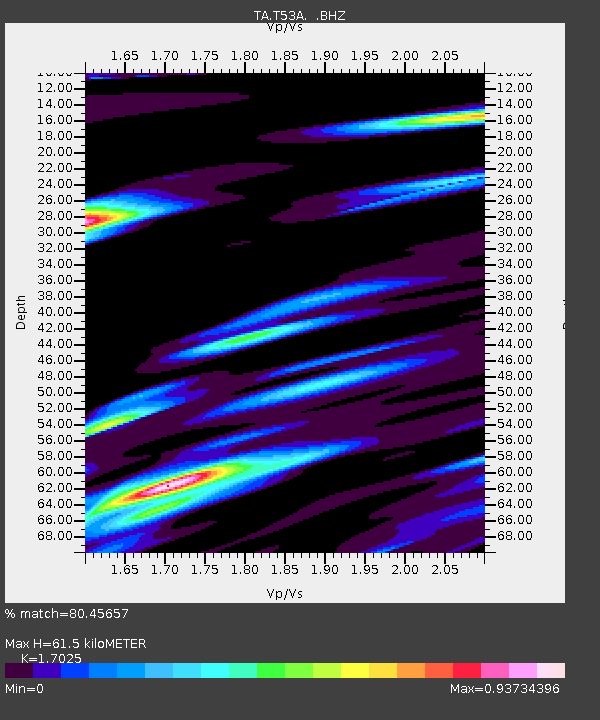
T53A Wise, VA, USA - Earthquake Result Viewer

Earthquake location: Andreanof Islands, Aleutian Is.
Earthquake latitude/longitude: 51.6/-174.8
Earthquake time(UTC): 2013/09/04 (247) 06:16:49 GMT
Earthquake Depth: 21 km
Earthquake Magnitude: 5.7 MWW, 5.5 ML, 5.5 MI, 5.7 MWB, 5.7 MWW, 5.8 MWC
Earthquake Catalog/Contributor: NEIC PDE/NEIC COMCAT
Network: TA USArray Transportable Network (new EarthScope stations)
Station: T53A Wise, VA, USA
Lat/Lon: 36.98 N/82.54 W
Elevation: 818 m
Distance: 63.4 deg
Az: 63.53 deg
Baz: 315.761 deg
Ray Param: 0.059603225
Estimated Moho Depth: 61.5 km
Estimated Crust Vp/Vs: 1.70
Assumed Crust Vp: 6.476 km/s
Estimated Crust Vs: 3.804 km/s
Estimated Crust Poisson's Ratio: 0.24
Radial Match: 80.45657 %
Radial Bump: 400
Transverse Match: 65.55985 %
Transverse Bump: 400
SOD ConfigId: 626651
Insert Time: 2014-04-18 11:26:54.679 +0000
GWidth: 2.5
Max Bumps: 400
Tol: 0.001

Signal To Noise

ChannelStoNSTALTA
TA:T53A: :BHZ:20130904T06:26:46.374006Z5.15919648.305628E-71.6098684E-7
TA:T53A: :BHN:20130904T06:26:46.374006Z2.3410363.120102E-71.3327868E-7
TA:T53A: :BHE:20130904T06:26:46.374006Z2.94476133.2267306E-71.0957529E-7
Arrivals
Ps7.0 SECOND
PpPs25 SECOND
PsPs/PpSs31 SECOND