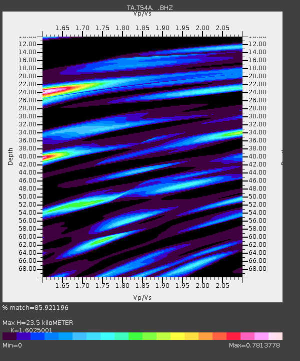
T54A Tazewell, VA, USA - Earthquake Result Viewer
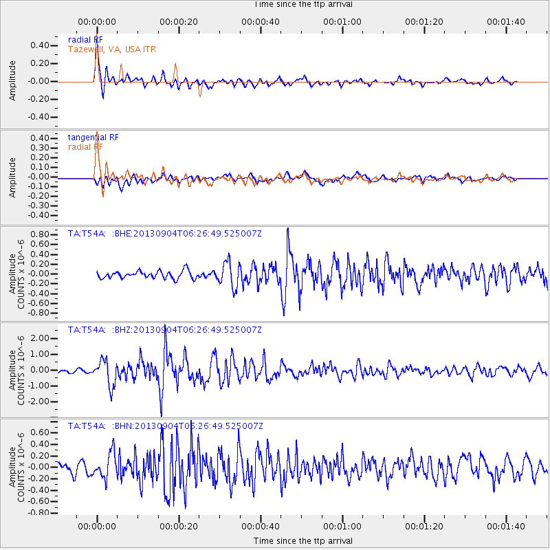
Earthquake location: Andreanof Islands, Aleutian Is.
Earthquake latitude/longitude: 51.6/-174.8
Earthquake time(UTC): 2013/09/04 (247) 06:16:49 GMT
Earthquake Depth: 21 km
Earthquake Magnitude: 5.7 MWW, 5.5 ML, 5.5 MI, 5.7 MWB, 5.7 MWW, 5.8 MWC
Earthquake Catalog/Contributor: NEIC PDE/NEIC COMCAT
Network: TA USArray Transportable Network (new EarthScope stations)
Station: T54A Tazewell, VA, USA
Lat/Lon: 37.06 N/81.58 W
Elevation: 852 m
Distance: 63.8 deg
Az: 62.853 deg
Baz: 316.035 deg
Ray Param: 0.05929119
Estimated Moho Depth: 23.5 km
Estimated Crust Vp/Vs: 1.60
Assumed Crust Vp: 6.159 km/s
Estimated Crust Vs: 3.843 km/s
Estimated Crust Poisson's Ratio: 0.18
Radial Match: 85.921196 %
Radial Bump: 400
Transverse Match: 64.33771 %
Transverse Bump: 400
SOD ConfigId: 626651
Insert Time: 2014-04-18 11:26:59.033 +0000
GWidth: 2.5
Max Bumps: 400
Tol: 0.001

Signal To Noise

ChannelStoNSTALTA
TA:T54A: :BHZ:20130904T06:26:49.525007Z10.2930678.22517E-77.99098E-8
TA:T54A: :BHN:20130904T06:26:49.525007Z2.80055452.2489931E-78.030528E-8
TA:T54A: :BHE:20130904T06:26:49.525007Z3.40906722.5367729E-77.4412526E-8
Arrivals
Ps2.4 SECOND
PpPs9.5 SECOND
PsPs/PpSs12 SECOND