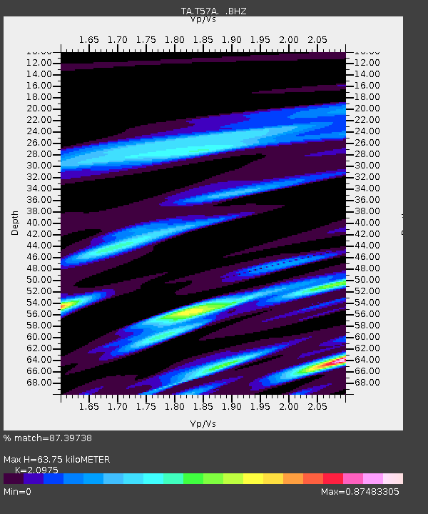
T57A Hurt, VA, USA - Earthquake Result Viewer
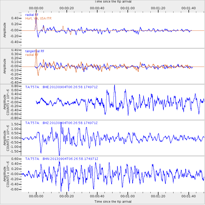
Earthquake location: Andreanof Islands, Aleutian Is.
Earthquake latitude/longitude: 51.6/-174.8
Earthquake time(UTC): 2013/09/04 (247) 06:16:49 GMT
Earthquake Depth: 21 km
Earthquake Magnitude: 5.7 MWW, 5.5 ML, 5.5 MI, 5.7 MWB, 5.7 MWW, 5.8 MWC
Earthquake Catalog/Contributor: NEIC PDE/NEIC COMCAT
Network: TA USArray Transportable Network (new EarthScope stations)
Station: T57A Hurt, VA, USA
Lat/Lon: 37.00 N/79.25 W
Elevation: 230 m
Distance: 65.2 deg
Az: 61.409 deg
Baz: 316.807 deg
Ray Param: 0.05842761
Estimated Moho Depth: 63.75 km
Estimated Crust Vp/Vs: 2.10
Assumed Crust Vp: 6.419 km/s
Estimated Crust Vs: 3.06 km/s
Estimated Crust Poisson's Ratio: 0.35
Radial Match: 87.39738 %
Radial Bump: 400
Transverse Match: 73.547104 %
Transverse Bump: 400
SOD ConfigId: 626651
Insert Time: 2014-04-18 11:27:04.356 +0000
GWidth: 2.5
Max Bumps: 400
Tol: 0.001

Signal To Noise

ChannelStoNSTALTA
TA:T57A: :BHZ:20130904T06:26:58.174971Z5.40053656.5981897E-71.2217656E-7
TA:T57A: :BHN:20130904T06:26:58.174971Z2.69397881.6536495E-76.138317E-8
TA:T57A: :BHE:20130904T06:26:58.174971Z1.8176511.7023612E-79.365721E-8
Arrivals
Ps11 SECOND
PpPs30 SECOND
PsPs/PpSs41 SECOND