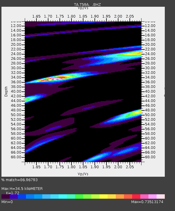
T59A Double 'B' Farms, VA, USA - Earthquake Result Viewer

Earthquake location: Andreanof Islands, Aleutian Is.
Earthquake latitude/longitude: 51.6/-174.8
Earthquake time(UTC): 2013/09/04 (247) 06:16:49 GMT
Earthquake Depth: 21 km
Earthquake Magnitude: 5.7 MWW, 5.5 ML, 5.5 MI, 5.7 MWB, 5.7 MWW, 5.8 MWC
Earthquake Catalog/Contributor: NEIC PDE/NEIC COMCAT
Network: TA USArray Transportable Network (new EarthScope stations)
Station: T59A Double 'B' Farms, VA, USA
Lat/Lon: 36.97 N/77.55 W
Elevation: 63 m
Distance: 66.1 deg
Az: 60.335 deg
Baz: 317.381 deg
Ray Param: 0.05780706
Estimated Moho Depth: 34.5 km
Estimated Crust Vp/Vs: 1.72
Assumed Crust Vp: 6.565 km/s
Estimated Crust Vs: 3.817 km/s
Estimated Crust Poisson's Ratio: 0.24
Radial Match: 86.96793 %
Radial Bump: 400
Transverse Match: 49.989674 %
Transverse Bump: 400
SOD ConfigId: 626651
Insert Time: 2014-04-18 11:27:09.354 +0000
GWidth: 2.5
Max Bumps: 400
Tol: 0.001

Signal To Noise

ChannelStoNSTALTA
TA:T59A: :BHZ:20130904T06:27:04.27397Z6.8104098.708006E-71.2786319E-7
TA:T59A: :BHN:20130904T06:27:04.27397Z4.0372613.5009953E-78.6717094E-8
TA:T59A: :BHE:20130904T06:27:04.27397Z2.02731062.9921495E-71.4759206E-7
Arrivals
Ps4.0 SECOND
PpPs14 SECOND
PsPs/PpSs18 SECOND