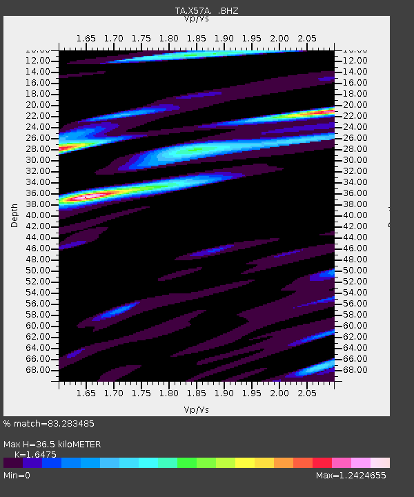
X57A Johnson Farm, Hartsville, SC, USA - Earthquake Result Viewer
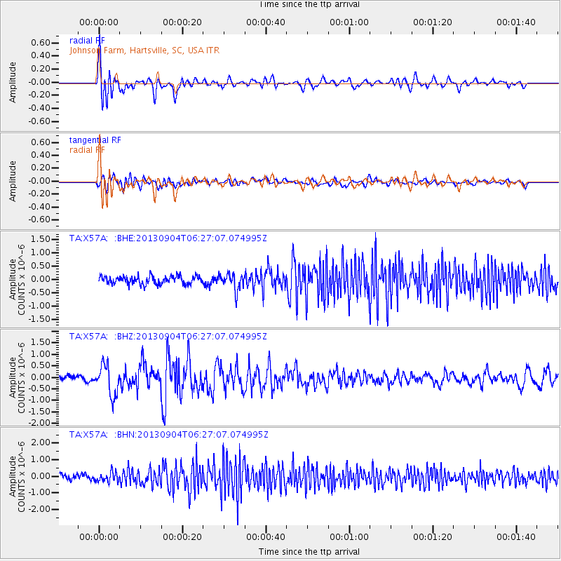
Earthquake location: Andreanof Islands, Aleutian Is.
Earthquake latitude/longitude: 51.6/-174.8
Earthquake time(UTC): 2013/09/04 (247) 06:16:49 GMT
Earthquake Depth: 21 km
Earthquake Magnitude: 5.7 MWW, 5.5 ML, 5.5 MI, 5.7 MWB, 5.7 MWW, 5.8 MWC
Earthquake Catalog/Contributor: NEIC PDE/NEIC COMCAT
Network: TA USArray Transportable Network (new EarthScope stations)
Station: X57A Johnson Farm, Hartsville, SC, USA
Lat/Lon: 34.46 N/80.09 W
Elevation: 133 m
Distance: 66.6 deg
Az: 63.845 deg
Baz: 317.314 deg
Ray Param: 0.057518605
Estimated Moho Depth: 36.5 km
Estimated Crust Vp/Vs: 1.65
Assumed Crust Vp: 6.419 km/s
Estimated Crust Vs: 3.896 km/s
Estimated Crust Poisson's Ratio: 0.21
Radial Match: 83.283485 %
Radial Bump: 400
Transverse Match: 69.2579 %
Transverse Bump: 400
SOD ConfigId: 626651
Insert Time: 2014-04-18 11:29:21.388 +0000
GWidth: 2.5
Max Bumps: 400
Tol: 0.001

Signal To Noise

ChannelStoNSTALTA
TA:X57A: :BHZ:20130904T06:27:07.074995Z4.0411896.721649E-71.6632848E-7
TA:X57A: :BHN:20130904T06:27:07.074995Z1.75931512.9216656E-71.6606835E-7
TA:X57A: :BHE:20130904T06:27:07.074995Z2.1461793.193363E-71.4879295E-7
Arrivals
Ps3.8 SECOND
PpPs14 SECOND
PsPs/PpSs18 SECOND