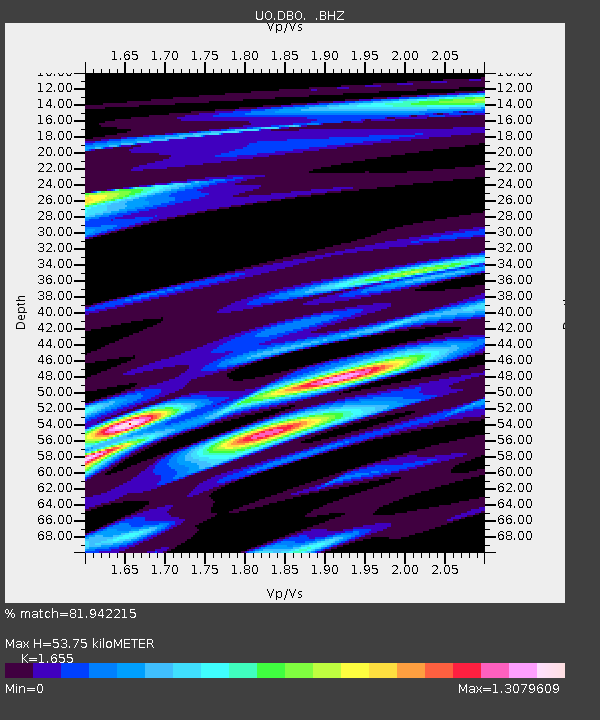
DBO Dodson Butte, OR (UO CREST BB SMO) - Earthquake Result Viewer

Earthquake location: Andreanof Islands, Aleutian Is.
Earthquake latitude/longitude: 51.6/-174.8
Earthquake time(UTC): 2013/09/04 (247) 06:16:49 GMT
Earthquake Depth: 21 km
Earthquake Magnitude: 5.7 MWW, 5.5 ML, 5.5 MI, 5.7 MWB, 5.7 MWW, 5.8 MWC
Earthquake Catalog/Contributor: NEIC PDE/NEIC COMCAT
Network: UO University of Oregon Regional Network
Station: DBO Dodson Butte, OR (UO CREST BB SMO)
Lat/Lon: 43.12 N/123.24 W
Elevation: 984 m
Distance: 35.3 deg
Az: 83.116 deg
Baz: 302.204 deg
Ray Param: 0.07728054
Estimated Moho Depth: 53.75 km
Estimated Crust Vp/Vs: 1.65
Assumed Crust Vp: 6.522 km/s
Estimated Crust Vs: 3.941 km/s
Estimated Crust Poisson's Ratio: 0.21
Radial Match: 81.942215 %
Radial Bump: 400
Transverse Match: 60.556805 %
Transverse Bump: 400
SOD ConfigId: 626651
Insert Time: 2014-04-18 11:30:51.375 +0000
GWidth: 2.5
Max Bumps: 400
Tol: 0.001

Signal To Noise

ChannelStoNSTALTA
UO:DBO: :BHZ:20130904T06:23:12.419996Z2.28104234.282072E-71.8772435E-7
UO:DBO: :BHN:20130904T06:23:12.419996Z1.42903721.6350222E-71.1441424E-7
UO:DBO: :BHE:20130904T06:23:12.419996Z1.95132213.2693973E-71.6754781E-7
Arrivals
Ps5.9 SECOND
PpPs20 SECOND
PsPs/PpSs26 SECOND