You are here: Home > Network List > UW - Pacific Northwest Regional Seismic Network Stations List
> Station MRBL Marblemount, WA, USA > Earthquake Result Viewer
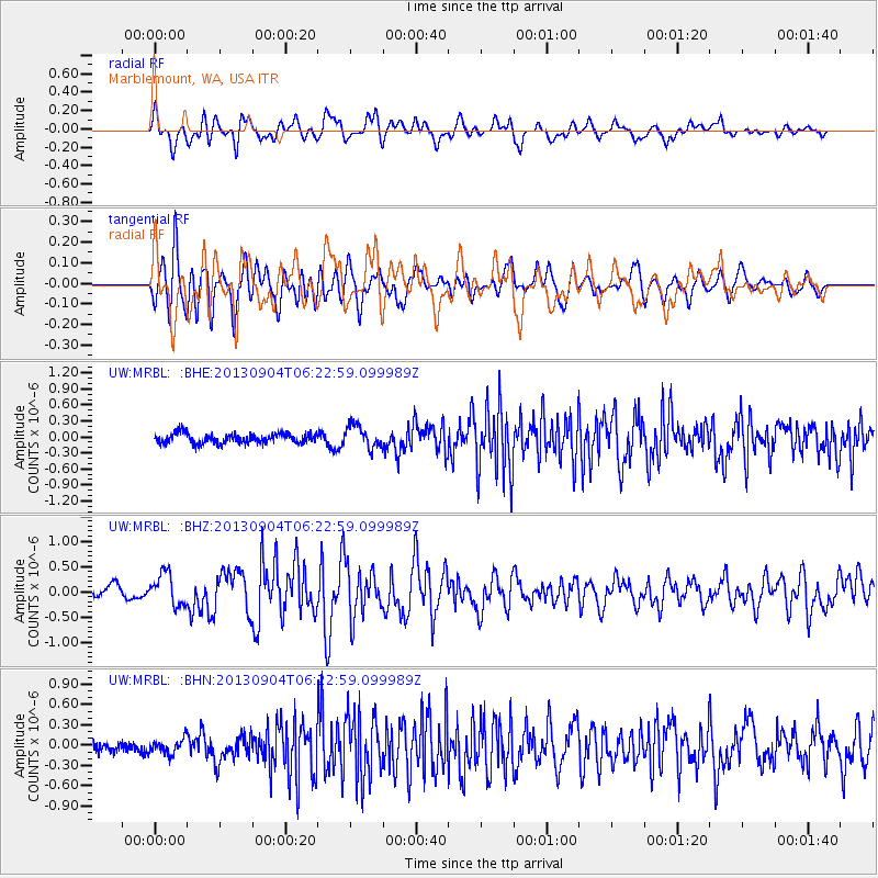
MRBL Marblemount, WA, USA - Earthquake Result Viewer
*The percent match for this event was below the threshold and hence no stack was calculated.
| Earthquake location: |
Andreanof Islands, Aleutian Is. |
| Earthquake latitude/longitude: |
51.6/-174.8 |
| Earthquake time(UTC): |
2013/09/04 (247) 06:16:49 GMT |
| Earthquake Depth: |
21 km |
| Earthquake Magnitude: |
5.7 MWW, 5.5 ML, 5.5 MI, 5.7 MWB, 5.7 MWW, 5.8 MWC |
| Earthquake Catalog/Contributor: |
NEIC PDE/NEIC COMCAT |
|
| Network: |
UW Pacific Northwest Regional Seismic Network |
| Station: |
MRBL Marblemount, WA, USA |
| Lat/Lon: |
48.52 N/121.48 W |
| Elevation: |
75 m |
|
| Distance: |
33.7 deg |
| Az: |
73.718 deg |
| Baz: |
295.712 deg |
| Ray Param: |
$rayparam |
*The percent match for this event was below the threshold and hence was not used in the summary stack. |
|
| Radial Match: |
72.13674 % |
| Radial Bump: |
400 |
| Transverse Match: |
70.11022 % |
| Transverse Bump: |
400 |
| SOD ConfigId: |
626651 |
| Insert Time: |
2014-04-18 11:34:02.004 +0000 |
| GWidth: |
2.5 |
| Max Bumps: |
400 |
| Tol: |
0.001 |
|
Signal To Noise
| Channel | StoN | STA | LTA |
| UW:MRBL: :BHZ:20130904T06:22:59.099989Z | 2.5646307 | 3.1479954E-7 | 1.2274653E-7 |
| UW:MRBL: :BHN:20130904T06:22:59.099989Z | 1.4335002 | 1.08464796E-7 | 7.566431E-8 |
| UW:MRBL: :BHE:20130904T06:22:59.099989Z | 2.3171067 | 2.105276E-7 | 9.085797E-8 |
| Arrivals |
| Ps | |
| PpPs | |
| PsPs/PpSs | |


