You are here: Home > Network List > II - Global Seismograph Network (GSN - IRIS/IDA) Stations List
> Station ARU Arti, Russia > Earthquake Result Viewer
ARU Arti, Russia - Earthquake Result Viewer

| Earthquake location: |
Off Coast Of Oregon |
| Earthquake latitude/longitude: |
42.1/-125.6 |
| Earthquake time(UTC): |
1991/07/13 (194) 02:50:14 GMT |
| Earthquake Depth: |
10 km |
| Earthquake Magnitude: |
6.4 MB, 6.9 MS, 6.7 ML |
| Earthquake Catalog/Contributor: |
WHDF/NEIC |
|
| Network: |
II Global Seismograph Network (GSN - IRIS/IDA) |
| Station: |
ARU Arti, Russia |
| Lat/Lon: |
56.43 N/58.56 E |
| Elevation: |
250 m |
|
| Distance: |
81.7 deg |
| Az: |
357.659 deg |
| Baz: |
3.135 deg |
| Ray Param: |
0.047374863 |
| Estimated Moho Depth: |
40.75 km |
| Estimated Crust Vp/Vs: |
1.65 |
| Assumed Crust Vp: |
6.159 km/s |
| Estimated Crust Vs: |
3.738 km/s |
| Estimated Crust Poisson's Ratio: |
0.21 |
|
| Radial Match: |
97.22802 % |
| Radial Bump: |
341 |
| Transverse Match: |
88.50322 % |
| Transverse Bump: |
400 |
| SOD ConfigId: |
61242 |
| Insert Time: |
2010-03-01 16:38:19.069 +0000 |
| GWidth: |
2.5 |
| Max Bumps: |
400 |
| Tol: |
0.001 |
|
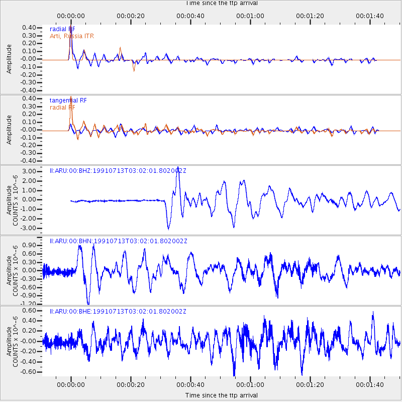
Signal To Noise
| Channel | StoN | STA | LTA |
| II:ARU:00:BHN:19910713T03:02:01.802002Z | 4.4516015 | 4.4368338E-7 | 9.966826E-8 |
| II:ARU:00:BHE:19910713T03:02:01.802002Z | 1.1024497 | 1.11273735E-7 | 1.00933164E-7 |
| II:ARU:00:BHZ:19910713T03:02:01.802002Z | 29.080906 | 1.3126518E-6 | 4.5137927E-8 |
| Arrivals |
| Ps | 4.4 SECOND |
| PpPs | 17 SECOND |
| PsPs/PpSs | 21 SECOND |


