You are here: Home > Network List > IU - Global Seismograph Network (GSN - IRIS/USGS) Stations List
> Station JOHN Johnston Island, USA > Earthquake Result Viewer
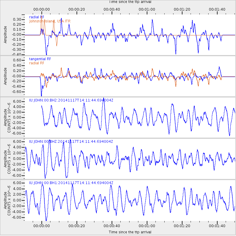
JOHN Johnston Island, USA - Earthquake Result Viewer
*The percent match for this event was below the threshold and hence no stack was calculated.
| Earthquake location: |
Philippine Islands Region |
| Earthquake latitude/longitude: |
19.5/120.4 |
| Earthquake time(UTC): |
2014/11/17 (321) 14:01:28 GMT |
| Earthquake Depth: |
13 km |
| Earthquake Magnitude: |
5.4 MW, 5.3 mb, 4.9 MS |
| Earthquake Catalog/Contributor: |
ISC/ISC |
|
| Network: |
IU Global Seismograph Network (GSN - IRIS/USGS) |
| Station: |
JOHN Johnston Island, USA |
| Lat/Lon: |
16.73 N/169.53 W |
| Elevation: |
2.0 m |
|
| Distance: |
66.2 deg |
| Az: |
79.86 deg |
| Baz: |
284.332 deg |
| Ray Param: |
$rayparam |
*The percent match for this event was below the threshold and hence was not used in the summary stack. |
|
| Radial Match: |
70.328735 % |
| Radial Bump: |
400 |
| Transverse Match: |
52.73723 % |
| Transverse Bump: |
400 |
| SOD ConfigId: |
3390531 |
| Insert Time: |
2019-04-15 01:52:38.477 +0000 |
| GWidth: |
2.5 |
| Max Bumps: |
400 |
| Tol: |
0.001 |
|
Signal To Noise
| Channel | StoN | STA | LTA |
| IU:JOHN:00:BHZ:20141117T14:11:44.694004Z | 2.4015276 | 4.364675E-6 | 1.8174578E-6 |
| IU:JOHN:00:BH1:20141117T14:11:44.694004Z | 1.4037963 | 4.2134E-6 | 3.0014326E-6 |
| IU:JOHN:00:BH2:20141117T14:11:44.694004Z | 1.0073017 | 2.555546E-6 | 2.5370214E-6 |
| Arrivals |
| Ps | |
| PpPs | |
| PsPs/PpSs | |


