You are here: Home > Network List > II - Global Seismograph Network (GSN - IRIS/IDA) Stations List
> Station ARU Arti, Russia > Earthquake Result Viewer
ARU Arti, Russia - Earthquake Result Viewer
| Earthquake location: |
Banda Sea |
| Earthquake latitude/longitude: |
-7.5/126.6 |
| Earthquake time(UTC): |
1991/05/21 (141) 11:00:21 GMT |
| Earthquake Depth: |
31 km |
| Earthquake Magnitude: |
6.2 MB, 6.4 MS |
| Earthquake Catalog/Contributor: |
WHDF/NEIC |
|
| Network: |
II Global Seismograph Network (GSN - IRIS/IDA) |
| Station: |
ARU Arti, Russia |
| Lat/Lon: |
56.43 N/58.56 E |
| Elevation: |
250 m |
|
| Distance: |
84.4 deg |
| Az: |
328.829 deg |
| Baz: |
112.514 deg |
| Ray Param: |
0.04548966 |
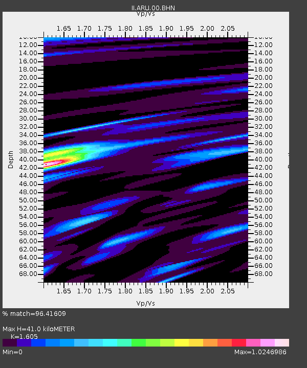
| Estimated Moho Depth: |
41.0 km |
| Estimated Crust Vp/Vs: |
1.61 |
| Assumed Crust Vp: |
6.159 km/s |
| Estimated Crust Vs: |
3.837 km/s |
| Estimated Crust Poisson's Ratio: |
0.18 |
|
| Radial Match: |
96.41609 % |
| Radial Bump: |
370 |
| Transverse Match: |
79.598785 % |
| Transverse Bump: |
400 |
| SOD ConfigId: |
16938 |
| Insert Time: |
2010-03-01 16:38:43.552 +0000 |
| GWidth: |
2.5 |
| Max Bumps: |
400 |
| Tol: |
0.001 |
|
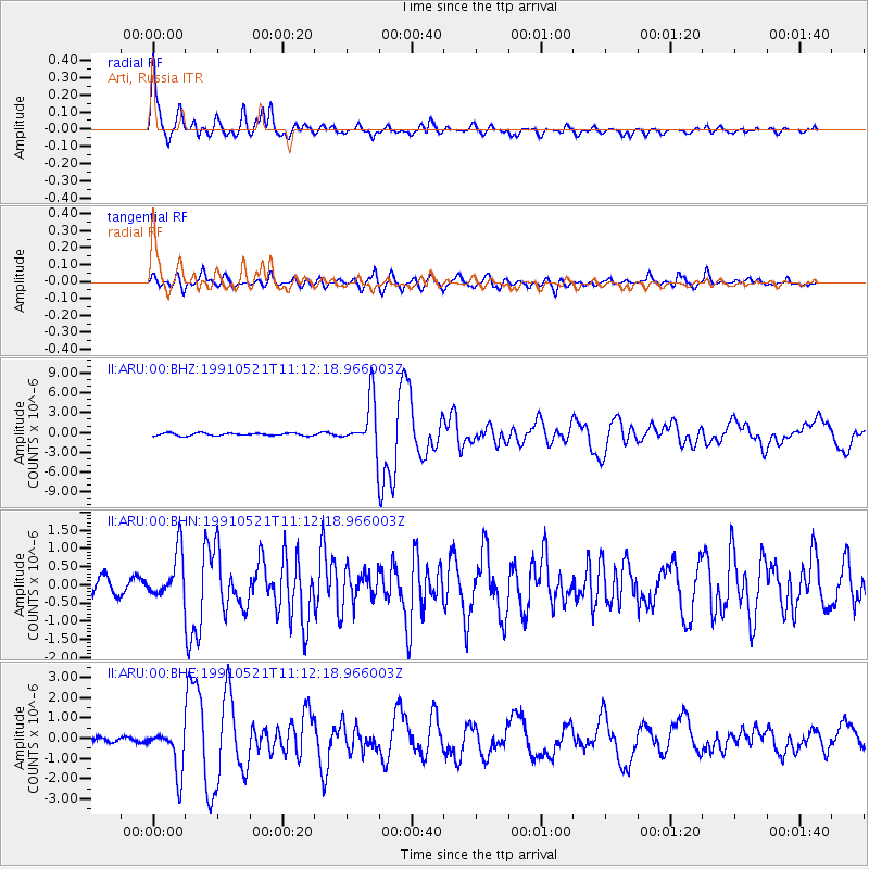
Signal To Noise
| Channel | StoN | STA | LTA |
| II:ARU:00:BHN:19910521T11:12:18.966003Z | 2.5837467 | 6.5491355E-7 | 2.5347438E-7 |
| II:ARU:00:BHE:19910521T11:12:18.966003Z | 7.347458 | 1.1144379E-6 | 1.5167666E-7 |
| II:ARU:00:BHZ:19910521T11:12:18.966003Z | 18.71554 | 3.7209095E-6 | 1.988139E-7 |
| Arrivals |
| Ps | 4.1 SECOND |
| PpPs | 17 SECOND |
| PsPs/PpSs | 21 SECOND |


