You are here: Home > Network List > CI - Caltech Regional Seismic Network Stations List
> Station TIN Tinemaha, California, USA > Earthquake Result Viewer
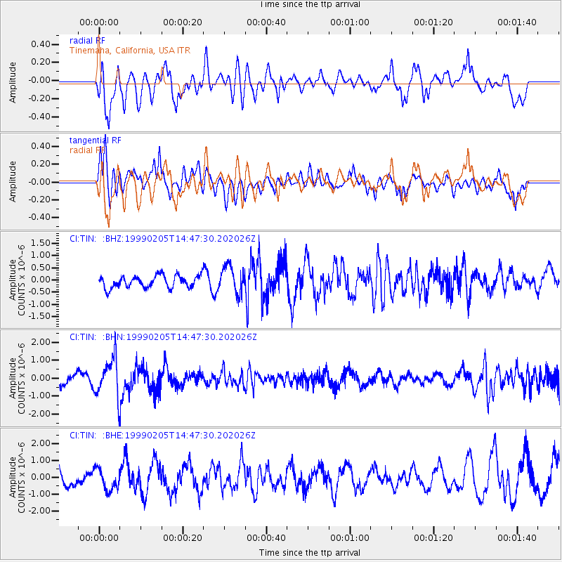
TIN Tinemaha, California, USA - Earthquake Result Viewer
*The percent match for this event was below the threshold and hence no stack was calculated.
| Earthquake location: |
Northwest Of Kuril Islands |
| Earthquake latitude/longitude: |
47.5/147.2 |
| Earthquake time(UTC): |
1999/02/05 (036) 14:37:53 GMT |
| Earthquake Depth: |
407 km |
| Earthquake Magnitude: |
6.0 MW, 5.4 MB, 5.8 MW |
| Earthquake Catalog/Contributor: |
WHDF/NEIC |
|
| Network: |
CI Caltech Regional Seismic Network |
| Station: |
TIN Tinemaha, California, USA |
| Lat/Lon: |
37.05 N/118.23 W |
| Elevation: |
1164 m |
|
| Distance: |
66.6 deg |
| Az: |
60.342 deg |
| Baz: |
312.57 deg |
| Ray Param: |
$rayparam |
*The percent match for this event was below the threshold and hence was not used in the summary stack. |
|
| Radial Match: |
71.14892 % |
| Radial Bump: |
400 |
| Transverse Match: |
71.77354 % |
| Transverse Bump: |
400 |
| SOD ConfigId: |
4480 |
| Insert Time: |
2010-02-25 20:51:51.678 +0000 |
| GWidth: |
2.5 |
| Max Bumps: |
400 |
| Tol: |
0.001 |
|
Signal To Noise
| Channel | StoN | STA | LTA |
| CI:TIN: :BHN:19990205T14:47:30.202026Z | 2.9029925 | 1.108864E-6 | 3.8197274E-7 |
| CI:TIN: :BHE:19990205T14:47:30.202026Z | 1.272747 | 6.435771E-7 | 5.056599E-7 |
| CI:TIN: :BHZ:19990205T14:47:30.202026Z | 2.2507722 | 5.556223E-7 | 2.4685852E-7 |
| Arrivals |
| Ps | |
| PpPs | |
| PsPs/PpSs | |


