You are here: Home > Network List > II - Global Seismograph Network (GSN - IRIS/IDA) Stations List
> Station ARU Arti, Russia > Earthquake Result Viewer
ARU Arti, Russia - Earthquake Result Viewer
| Earthquake location: |
Off East Coast Of Kamchatka |
| Earthquake latitude/longitude: |
52.9/160.0 |
| Earthquake time(UTC): |
1992/03/02 (062) 12:29:40 GMT |
| Earthquake Depth: |
44 km |
| Earthquake Magnitude: |
6.5 MB, 6.8 MS, 6.7 UNKNOWN |
| Earthquake Catalog/Contributor: |
WHDF/NEIC |
|
| Network: |
II Global Seismograph Network (GSN - IRIS/IDA) |
| Station: |
ARU Arti, Russia |
| Lat/Lon: |
56.43 N/58.56 E |
| Elevation: |
250 m |
|
| Distance: |
53.5 deg |
| Az: |
317.369 deg |
| Baz: |
47.63 deg |
| Ray Param: |
0.0659487 |
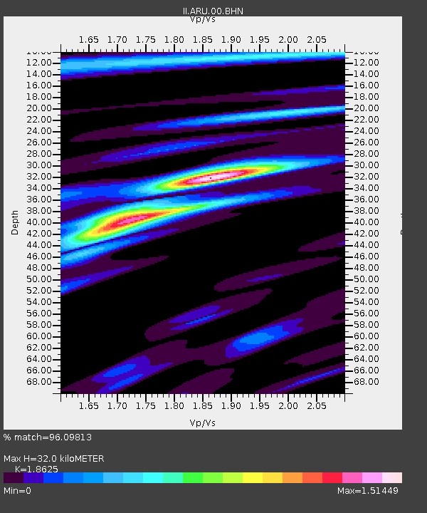
| Estimated Moho Depth: |
32.0 km |
| Estimated Crust Vp/Vs: |
1.86 |
| Assumed Crust Vp: |
6.159 km/s |
| Estimated Crust Vs: |
3.307 km/s |
| Estimated Crust Poisson's Ratio: |
0.30 |
|
| Radial Match: |
96.09813 % |
| Radial Bump: |
316 |
| Transverse Match: |
80.72861 % |
| Transverse Bump: |
400 |
| SOD ConfigId: |
61242 |
| Insert Time: |
2010-03-01 16:38:51.549 +0000 |
| GWidth: |
2.5 |
| Max Bumps: |
400 |
| Tol: |
0.001 |
|

Signal To Noise
| Channel | StoN | STA | LTA |
| II:ARU:00:BHN:19920302T12:38:25.668994Z | 20.345112 | 2.2587622E-6 | 1.11022345E-7 |
| II:ARU:00:BHE:19920302T12:38:25.668994Z | 17.784704 | 2.6529058E-6 | 1.4916782E-7 |
| II:ARU:00:BHZ:19920302T12:38:25.668994Z | 56.802208 | 6.431291E-6 | 1.1322255E-7 |
| Arrivals |
| Ps | 4.7 SECOND |
| PpPs | 14 SECOND |
| PsPs/PpSs | 19 SECOND |


