You are here: Home > Network List > AV - Alaska Volcano Observatory Stations List
> Station AKRB Akutan Reef Bight, Akutan Volcano, Alaska > Earthquake Result Viewer
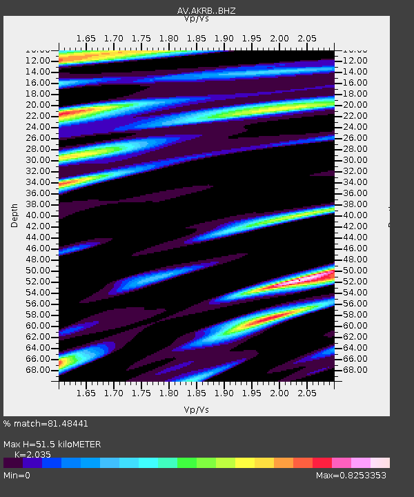
AKRB Akutan Reef Bight, Akutan Volcano, Alaska - Earthquake Result Viewer
| Earthquake location: |
Philippine Islands Region |
| Earthquake latitude/longitude: |
19.6/120.5 |
| Earthquake time(UTC): |
2014/11/17 (321) 14:13:43 GMT |
| Earthquake Depth: |
23 km |
| Earthquake Magnitude: |
5.2 MW, 5.3 mb, 4.9 MS |
| Earthquake Catalog/Contributor: |
ISC/ISC |
|
| Network: |
AV Alaska Volcano Observatory |
| Station: |
AKRB Akutan Reef Bight, Akutan Volcano, Alaska |
| Lat/Lon: |
54.13 N/166.07 W |
| Elevation: |
334 m |
|
| Distance: |
64.7 deg |
| Az: |
38.61 deg |
| Baz: |
268.674 deg |
| Ray Param: |
0.0587191 |
| Estimated Moho Depth: |
51.5 km |
| Estimated Crust Vp/Vs: |
2.04 |
| Assumed Crust Vp: |
5.989 km/s |
| Estimated Crust Vs: |
2.943 km/s |
| Estimated Crust Poisson's Ratio: |
0.34 |
|
| Radial Match: |
81.48441 % |
| Radial Bump: |
400 |
| Transverse Match: |
63.92996 % |
| Transverse Bump: |
400 |
| SOD ConfigId: |
3390531 |
| Insert Time: |
2019-04-15 01:59:01.493 +0000 |
| GWidth: |
2.5 |
| Max Bumps: |
400 |
| Tol: |
0.001 |
|

Signal To Noise
| Channel | StoN | STA | LTA |
| AV:AKRB: :BHZ:20141117T14:23:48.140015Z | 3.0284705 | 6.203015E-6 | 2.0482335E-6 |
| AV:AKRB: :BHN:20141117T14:23:48.140015Z | 2.4007494 | 5.26637E-6 | 2.1936357E-6 |
| AV:AKRB: :BHE:20141117T14:23:48.140015Z | 2.861519 | 6.1522132E-6 | 2.1499816E-6 |
| Arrivals |
| Ps | 9.2 SECOND |
| PpPs | 25 SECOND |
| PsPs/PpSs | 34 SECOND |


