You are here: Home > Network List > TA - USArray Transportable Network (new EarthScope stations) Stations List
> Station D46A Sault St. Marie, ON, CAN > Earthquake Result Viewer
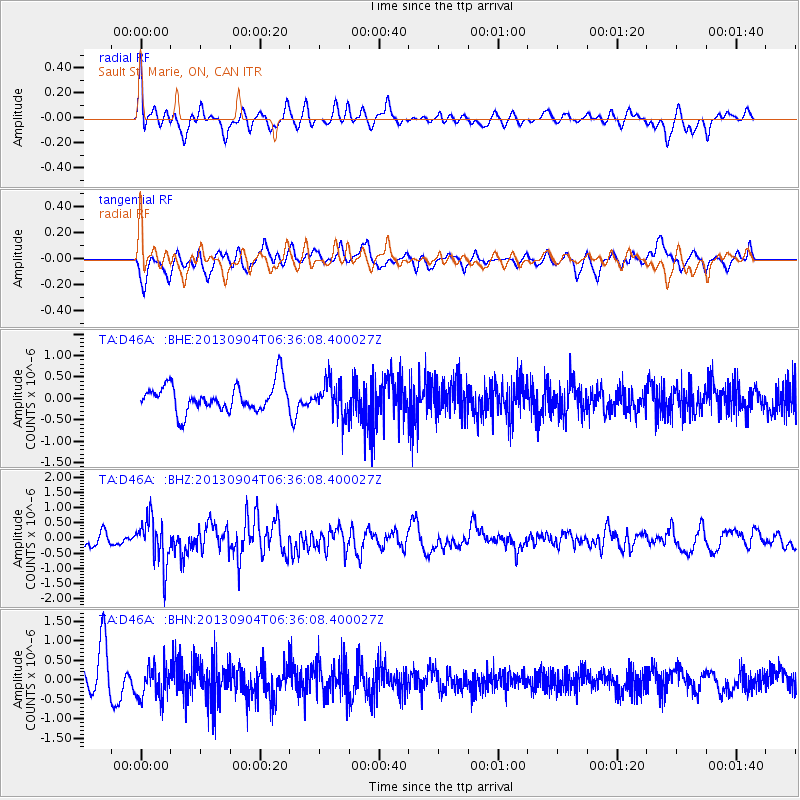
D46A Sault St. Marie, ON, CAN - Earthquake Result Viewer
*The percent match for this event was below the threshold and hence no stack was calculated.
| Earthquake location: |
Andreanof Islands, Aleutian Is. |
| Earthquake latitude/longitude: |
51.6/-174.9 |
| Earthquake time(UTC): |
2013/09/04 (247) 06:27:03 GMT |
| Earthquake Depth: |
17 km |
| Earthquake Magnitude: |
6.0 MWW, 5.5 ML, 5.9 MWB, 6.0 MWW, 6.1 MWC, 6.1 MI |
| Earthquake Catalog/Contributor: |
NEIC PDE/NEIC COMCAT |
|
| Network: |
TA USArray Transportable Network (new EarthScope stations) |
| Station: |
D46A Sault St. Marie, ON, CAN |
| Lat/Lon: |
46.89 N/84.04 W |
| Elevation: |
353 m |
|
| Distance: |
55.8 deg |
| Az: |
56.042 deg |
| Baz: |
310.996 deg |
| Ray Param: |
$rayparam |
*The percent match for this event was below the threshold and hence was not used in the summary stack. |
|
| Radial Match: |
61.38573 % |
| Radial Bump: |
400 |
| Transverse Match: |
37.516125 % |
| Transverse Bump: |
385 |
| SOD ConfigId: |
626651 |
| Insert Time: |
2014-04-18 11:56:33.894 +0000 |
| GWidth: |
2.5 |
| Max Bumps: |
400 |
| Tol: |
0.001 |
|
Signal To Noise
| Channel | StoN | STA | LTA |
| TA:D46A: :BHZ:20130904T06:36:08.400027Z | 2.9021368 | 7.715561E-7 | 2.6585792E-7 |
| TA:D46A: :BHN:20130904T06:36:08.400027Z | 1.0310215 | 4.3005664E-7 | 4.1711706E-7 |
| TA:D46A: :BHE:20130904T06:36:08.400027Z | 1.2787957 | 4.066191E-7 | 3.1797035E-7 |
| Arrivals |
| Ps | |
| PpPs | |
| PsPs/PpSs | |


