You are here: Home > Network List > II - Global Seismograph Network (GSN - IRIS/IDA) Stations List
> Station WRAB Tennant Creek, NT, Australia > Earthquake Result Viewer
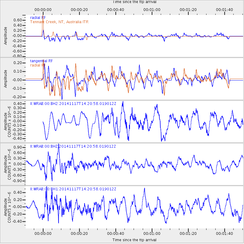
WRAB Tennant Creek, NT, Australia - Earthquake Result Viewer
*The percent match for this event was below the threshold and hence no stack was calculated.
| Earthquake location: |
Philippine Islands Region |
| Earthquake latitude/longitude: |
19.6/120.5 |
| Earthquake time(UTC): |
2014/11/17 (321) 14:13:43 GMT |
| Earthquake Depth: |
23 km |
| Earthquake Magnitude: |
5.2 MW, 5.3 mb, 4.9 MS |
| Earthquake Catalog/Contributor: |
ISC/ISC |
|
| Network: |
II Global Seismograph Network (GSN - IRIS/IDA) |
| Station: |
WRAB Tennant Creek, NT, Australia |
| Lat/Lon: |
19.93 S/134.36 E |
| Elevation: |
366 m |
|
| Distance: |
41.6 deg |
| Az: |
160.086 deg |
| Baz: |
340.04 deg |
| Ray Param: |
$rayparam |
*The percent match for this event was below the threshold and hence was not used in the summary stack. |
|
| Radial Match: |
61.108868 % |
| Radial Bump: |
400 |
| Transverse Match: |
55.302116 % |
| Transverse Bump: |
400 |
| SOD ConfigId: |
3390531 |
| Insert Time: |
2019-04-15 02:00:12.012 +0000 |
| GWidth: |
2.5 |
| Max Bumps: |
400 |
| Tol: |
0.001 |
|
Signal To Noise
| Channel | StoN | STA | LTA |
| II:WRAB:00:BHZ:20141117T14:20:58.019012Z | 2.933721 | 4.0405197E-7 | 1.3772679E-7 |
| II:WRAB:00:BH1:20141117T14:20:58.019012Z | 2.481606 | 2.4581846E-7 | 9.90562E-8 |
| II:WRAB:00:BH2:20141117T14:20:58.019012Z | 1.1060435 | 1.6520983E-7 | 1.493701E-7 |
| Arrivals |
| Ps | |
| PpPs | |
| PsPs/PpSs | |


