You are here: Home > Network List > II - Global Seismograph Network (GSN - IRIS/IDA) Stations List
> Station ARU Arti, Russia > Earthquake Result Viewer
ARU Arti, Russia - Earthquake Result Viewer

| Earthquake location: |
Northeast Of Taiwan |
| Earthquake latitude/longitude: |
26.5/125.6 |
| Earthquake time(UTC): |
1993/08/07 (219) 00:00:37 GMT |
| Earthquake Depth: |
158 km |
| Earthquake Magnitude: |
6.0 MB, 6.4 UNKNOWN, 6.4 MW |
| Earthquake Catalog/Contributor: |
WHDF/NEIC |
|
| Network: |
II Global Seismograph Network (GSN - IRIS/IDA) |
| Station: |
ARU Arti, Russia |
| Lat/Lon: |
56.43 N/58.56 E |
| Elevation: |
250 m |
|
| Distance: |
55.7 deg |
| Az: |
321.746 deg |
| Baz: |
93.042 deg |
| Ray Param: |
0.064099215 |
| Estimated Moho Depth: |
39.25 km |
| Estimated Crust Vp/Vs: |
1.70 |
| Assumed Crust Vp: |
6.159 km/s |
| Estimated Crust Vs: |
3.633 km/s |
| Estimated Crust Poisson's Ratio: |
0.23 |
|
| Radial Match: |
96.8236 % |
| Radial Bump: |
344 |
| Transverse Match: |
86.1179 % |
| Transverse Bump: |
400 |
| SOD ConfigId: |
61242 |
| Insert Time: |
2010-03-01 16:40:11.970 +0000 |
| GWidth: |
2.5 |
| Max Bumps: |
400 |
| Tol: |
0.001 |
|
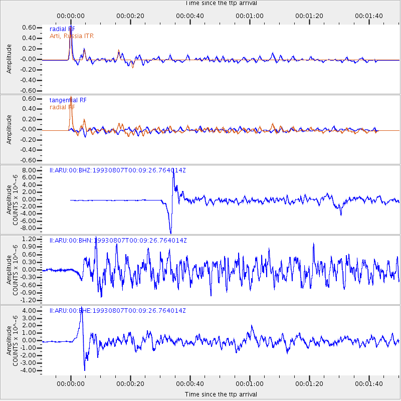
Signal To Noise
| Channel | StoN | STA | LTA |
| II:ARU:00:BHN:19930807T00:09:26.764014Z | 1.9653556 | 2.0595944E-7 | 1.04795E-7 |
| II:ARU:00:BHE:19930807T00:09:26.764014Z | 73.141 | 1.9698034E-6 | 2.693159E-8 |
| II:ARU:00:BHZ:19930807T00:09:26.764014Z | 87.79075 | 4.162993E-6 | 4.7419494E-8 |
| Arrivals |
| Ps | 4.6 SECOND |
| PpPs | 16 SECOND |
| PsPs/PpSs | 21 SECOND |


